
IMAGES TAKEN NEAR TO
Heol Merioneth, LLANTWIT MAJOR, CF61 2GS
Introduction
This page details the photographs taken nearby to Heol Merioneth, CF61 2GS by members of the Geograph project.
The Geograph project started in 2005 with the aim of publishing, organising and preserving representative images for every square kilometre of Great Britain, Ireland and the Isle of Man.

There are currently over 7.5m images from over14,400 individuals and you can help contribute to the project by visiting https://www.geograph.org.uk
Image Map
Images are licensed for reuse under creativecommons.org/licenses/by-sa/2.0
Notes
- Clicking on the map will re-center to the selected point.
- The higher the marker number, the further away the image location is from the centre of the postcode.
Image Listing (143 Images Found)
Images are licensed for reuse under creativecommons.org/licenses/by-sa/2.0
Image
Details
Distance
1
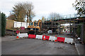
Road closed for Bridge replacement - Llantwit Major
The 114 year old railway bridge being replaced at Eagleswell Road at a cost of £700,000. It is estimated that the replacement will not require any further attention for 25 years and should last 125 years so I won't see the next one!
Image: © Mick Lobb
Taken: 19 Nov 2010
0.10 miles
2
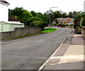
Towards a bend in Eagleswell Road, Boverton
This way for Llantwit Major in the Vale of Glamorgan.
Image: © Jaggery
Taken: 25 Sep 2019
0.11 miles
3
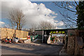
Road closed for Bridge replacement - Llantwit Major (updated)
The bridge at http://www.geograph.org.uk/photo/2166730 renewed and road re-opened.
Image: © Mick Lobb
Taken: 26 Feb 2011
0.11 miles
4
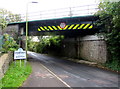
North side of Eagleswell Road railway bridge, Boverton
The bridge, identifier VOG 9 04.5, carries the Vale of Glamorgan Line railway.
Headroom shown is 4.3 metres/14' 0". A Welcome to Boverton sign https://www.geograph.org.uk/photo/6277168 is on the left.
Image: © Jaggery
Taken: 25 Sep 2019
0.11 miles
5
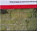
Ordnance Survey Cut Mark
This OS cut mark can be found on the SW side of the railway bridge. It marks a point 38.569m above mean sea level.
Image: © Adrian Dust
Taken: 11 Mar 2018
0.12 miles
6
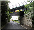
South side of Eagleswell Road railway bridge, Boverton
The Vale of Glamorgan Line is on the bridge, identifier VOG 9 04.5
Headroom shown is 4.3 metres/14' 0".
Image: © Jaggery
Taken: 25 Sep 2019
0.12 miles
7
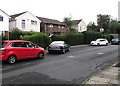
Cars, hedges and houses, Eagleswell Road, Llantwit Major
This part of Eagleswell Road is between the Monmouth Way junction and a Welcome to Boverton sign https://www.geograph.org.uk/photo/6277168 out of shot on the right.
Image: © Jaggery
Taken: 25 Sep 2019
0.12 miles
8
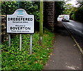
Welcome to Boverton - Please drive carefully
Facing Llantwit Major, the sign alongside Eagleswell Road shows that Welcome to Boverton
is Croeso i Drebefered in Welsh. Drebefered is a mutated form of Trebefered.
Image: © Jaggery
Taken: 25 Sep 2019
0.12 miles
9
Houses and hedges, Eagleswell Road, Boverton
Near the northern edge of Boverton on the approach to Llantwit Major.
Image: © Jaggery
Taken: 25 Sep 2019
0.12 miles
10
Monmouth Way, Llantwit Major
Looking to the NE along Monmouth Way from Eagleswell Road.
Image: © Jaggery
Taken: 25 Sep 2019
0.14 miles