IMAGES TAKEN NEAR TO
Cae Brewis, LLANTWIT MAJOR, CF61 2AU
Introduction
This page details the photographs taken nearby to Cae Brewis, CF61 2AU by members of the Geograph project.
The Geograph project started in 2005 with the aim of publishing, organising and preserving representative images for every square kilometre of Great Britain, Ireland and the Isle of Man.

There are currently over 7.5m images from over14,400 individuals and you can help contribute to the project by visiting https://www.geograph.org.uk
Image Map
Images are licensed for reuse under creativecommons.org/licenses/by-sa/2.0
Notes
- Clicking on the map will re-center to the selected point.
- The higher the marker number, the further away the image location is from the centre of the postcode.
Image Listing (48 Images Found)
Images are licensed for reuse under creativecommons.org/licenses/by-sa/2.0
Image
Details
Distance
2
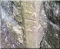
Ordnance Survey Cut Mark
This OS cut mark can be found on the NW side of the railway bridge. It marks a point 35.632m above mean sea level.
Image: © Adrian Dust
Taken: 11 Mar 2018
0.09 miles
3
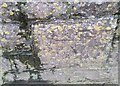
Ordnance Survey Cut Mark
This OS cut mark can be found on the Folly Tower. It marks a point 45.296m above mean sea level.
Image: © Adrian Dust
Taken: 11 Mar 2018
0.09 miles
5
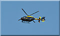
South Wales Police helicopter G-WONN - Boverton
Based at St Athan airfield, the helicopter is a Eurocopter EC 135.
Image: © Mick Lobb
Taken: 8 Aug 2009
0.10 miles
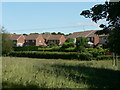
6
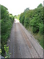
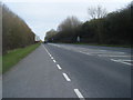
Vale of Glamorgan line near Boverton, looking NW
Image: © Gareth James
Taken: 11 Aug 2010
0.10 miles
7
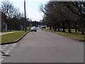
Kingfisher Square, West Camp, Saint Athan, Vale of Glamorgan
Junction of Kingfisher Square West (straight ahead) and Kingfisher Square North (to the left in photo).
Curlew Crescent is accessed by the junction just visible on bottom right of photo.
RAF Saint Athan, houses Army and RAF personnel and their families.
Some of the housing is now privately owned, the first phase of sales taking place in 2001.
All the roads on this estate are named after birds.
Image: © Kate Bee
Taken: 17 Mar 2010
0.10 miles
8
East along Boverton Road, Boverton
This is the dead-end part of Boverton Road which ends out of shot ahead near the B4265.
Image: © Jaggery
Taken: 25 Sep 2019
0.11 miles
9
Orchard Close, Boverton
Cul-de-sac east of Orchard Lodge, north of Boverton Road.
Image: © Jaggery
Taken: 25 Sep 2019
0.11 miles
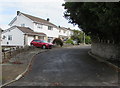
10
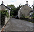
Church Meadow Estate, Boverton Nr Llantwit Major
Image: © Mick Lobb
Taken: 23 Jun 2008
0.11 miles