IMAGES TAKEN NEAR TO
Marcross, LLANTWIT MAJOR, CF61 1ZD
Introduction
This page details the photographs taken nearby to CF61 1ZD by members of the Geograph project.
The Geograph project started in 2005 with the aim of publishing, organising and preserving representative images for every square kilometre of Great Britain, Ireland and the Isle of Man.

There are currently over 7.5m images from over14,400 individuals and you can help contribute to the project by visiting https://www.geograph.org.uk
Image Map
Images are licensed for reuse under creativecommons.org/licenses/by-sa/2.0
Notes
- Clicking on the map will re-center to the selected point.
- The higher the marker number, the further away the image location is from the centre of the postcode.
Image Listing (6 Images Found)
Images are licensed for reuse under creativecommons.org/licenses/by-sa/2.0
Image
Details
Distance
1
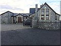
Old School House
The Old School House near Marcross.
Image: © Alan Hughes
Taken: 16 Dec 2016
0.00 miles
2
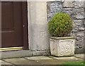
Ordnance Survey Cut Mark
This OS cut mark can be found on The Old School House. It marks a point 67.251m above mean sea level.
Image: © Adrian Dust
Taken: 31 Dec 2021
0.01 miles
3
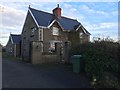
Marcross Court
Marcross Court, Dimlands Road.
Image: © Alan Hughes
Taken: 16 Dec 2016
0.03 miles
4
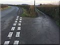
Road Junction
Track leading up from Parc Farm to junction with Dimlands Road.
Image: © Alan Hughes
Taken: 16 Dec 2016
0.07 miles
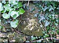
5
Ordnance Survey Cut Mark
This OS cut mark can be found on the wall next to the stile on the north side of the road. It marks a point 69.181m above mean sea level.
Image: © Adrian Dust
Taken: 31 Dec 2021
0.13 miles
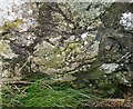
6
Ordnance Survey Cut Mark
This OS cut mark can be found on the wall NE side of the lane. It marks a point 59.162m above mean sea level.
Image: © Adrian Dust
Taken: 31 Dec 2021
0.17 miles