IMAGES TAKEN NEAR TO
Boverton Brook, LLANTWIT MAJOR, CF61 1YG
Introduction
This page details the photographs taken nearby to Boverton Brook, CF61 1YG by members of the Geograph project.
The Geograph project started in 2005 with the aim of publishing, organising and preserving representative images for every square kilometre of Great Britain, Ireland and the Isle of Man.

There are currently over 7.5m images from over14,400 individuals and you can help contribute to the project by visiting https://www.geograph.org.uk
Image Map
Images are licensed for reuse under creativecommons.org/licenses/by-sa/2.0
Notes
- Clicking on the map will re-center to the selected point.
- The higher the marker number, the further away the image location is from the centre of the postcode.
Image Listing (92 Images Found)
Images are licensed for reuse under creativecommons.org/licenses/by-sa/2.0
Image
Details
Distance
1
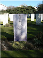
The grave of Sgt. R C Turner (Royal New Zealand Air Force) - Llantwit Major
Image: © Mick Lobb
Taken: 8 Mar 2010
0.02 miles
2
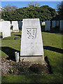
Grave of Flying Officer Josef Nejezchleba (Royal Air Force) - Llantwit Major
Though the headstone relates to Royal Air Force service, the emblem on the headstone indicates that this casualty of war was Czechoslovakian. One of many who were able to flee their homelands to fight a common enemy only to have their last resting place in this foreign field. Others of his nationality lie nearby. Perhaps they were victims of the same incident but who now will tell their story?
Image: © Mick Lobb
Taken: 8 Mar 2010
0.02 miles
3
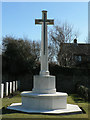
Memorial Cross - Llantwit Major
Located in a corner of the town cemetery the cross commemorates the lives of the RAF servicemen of several nations who are buried here. Some of those resting here died during peace time.
Image: © Mick Lobb
Taken: 8 Mar 2010
0.03 miles
4
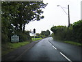
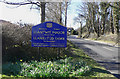
Boverton Road at Boverton village boundary
Image: © Colin Pyle
Taken: 16 Jul 2012
0.05 miles
5
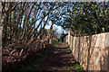
Footpath 'tween trees and fence - Boverton
Image: © Mick Lobb
Taken: 26 Feb 2011
0.05 miles
6
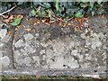
Ordnance Survey Rivet
This OS rivet can be found on the cemetery wall. It marks a point 35.340m above mean sea level.
Image: © Adrian Dust
Taken: 6 Sep 2022
0.07 miles
7
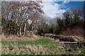
Bend and trees on the Hoddnant - Boverton
Image: © Mick Lobb
Taken: 26 Feb 2011
0.07 miles
9
Boverton Court, Boverton
Road on the west side of Eagleswell Road. The houses are opposite a green.
Image: © Jaggery
Taken: 25 Sep 2019
0.09 miles
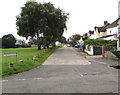
10

Green and trees in Boverton
Viewed from Eagleswell Road looking towards Boverton Court.
Image: © Jaggery
Taken: 25 Sep 2019
0.09 miles