1
Daisies in a playground - Llantwit Major
Image: © Mick Lobb
Taken: 20 Feb 2010
0.09 miles
2
Church of Our Lady and St.Illtyd
Church of Our Lady and St.Illtyd, Llantwit Major.
Image: © Alan Hughes
Taken: 29 Nov 2016
0.09 miles
3
Our Lady and St Illtyds Catholic Church, Llantwit Major.
Image: © Mick Lobb
Taken: 16 Feb 2009
0.13 miles
4
Ham Lane East - Llantwit Major
To the left, Llanilltyd Fawr Comprehensive School, aka Llantwit Major Comprehensive School, and the hills of Exmoor in the far distance across the Bristol Channel.
Image: © Mick Lobb
Taken: 20 Feb 2010
0.14 miles
5
Ham Lodge - Llantwit Major
Image: © Mick Lobb
Taken: 6 Jan 2010
0.15 miles
6
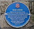
Ham Lodge
Cottage built in 1862 on the site of an older building, The Ham, the main home of the Nicholl family
Image: © Eirian Evans
Taken: 24 Jun 2021
0.16 miles
7
Local History Society Plaque Ham Lodge, Llantwit Major
Image: © Mick Lobb
Taken: 18 Nov 2008
0.16 miles
8
Entrance to comprehensive school and leisure centre, Llantwit Major
Viewed from Ham Lane East. Llantwit Major Comprehensive School is on the right,
Llantwit Major Leisure Centre is in the background on the left.
Image: © Jaggery
Taken: 9 Jul 2011
0.18 miles
9
Llantwit Major Leisure Centre
Located in the NE corner of the Llantwit Major Comprehensive School site, http://www.geograph.org.uk/photo/3493370 Ham Lane East.
Image: © Jaggery
Taken: 9 Jul 2011
0.18 miles
10
The Hoddnant flowing through woodland.
This is the only point on its journey to the sea that the river flows through woodland. It is also where it is at its most turbulent as it tumbles over rock. Sharing the location is a caravan park containing both residential homes and a touring caravan site.
Image: © Mick Lobb
Taken: 16 Feb 2009
0.18 miles


