IMAGES TAKEN NEAR TO
Fitzhamon Avenue, LLANTWIT MAJOR, CF61 1TP
Introduction
This page details the photographs taken nearby to Fitzhamon Avenue, CF61 1TP by members of the Geograph project.
The Geograph project started in 2005 with the aim of publishing, organising and preserving representative images for every square kilometre of Great Britain, Ireland and the Isle of Man.

There are currently over 7.5m images from over14,400 individuals and you can help contribute to the project by visiting https://www.geograph.org.uk
Image Map
Images are licensed for reuse under creativecommons.org/licenses/by-sa/2.0
Notes
- Clicking on the map will re-center to the selected point.
- The higher the marker number, the further away the image location is from the centre of the postcode.
Image Listing (22 Images Found)
Images are licensed for reuse under creativecommons.org/licenses/by-sa/2.0
Image
Details
Distance
1
Our Lady and St Illtyds Catholic Church, Llantwit Major.
Image: © Mick Lobb
Taken: 16 Feb 2009
0.06 miles
3
Church of Our Lady and St.Illtyd
Church of Our Lady and St.Illtyd, Llantwit Major.
Image: © Alan Hughes
Taken: 29 Nov 2016
0.08 miles
4
Ham Lane East - Llantwit Major
To the left, Llanilltyd Fawr Comprehensive School, aka Llantwit Major Comprehensive School, and the hills of Exmoor in the far distance across the Bristol Channel.
Image: © Mick Lobb
Taken: 20 Feb 2010
0.08 miles
5
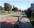
Ham Lane East, Llantwit Major
Ham Lane East heads south away from Boverton Road.
Image: © Jaggery
Taken: 9 Jul 2011
0.13 miles
6
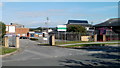
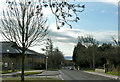
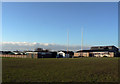
Entrance to comprehensive school and leisure centre, Llantwit Major
Viewed from Ham Lane East. Llantwit Major Comprehensive School is on the right,
Llantwit Major Leisure Centre is in the background on the left.
Image: © Jaggery
Taken: 9 Jul 2011
0.14 miles
7
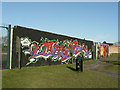
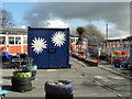
Bowling green wall - Llantwit Major
A play park has been built in a corner of the playing fields and the wall art has been applied to the wall of the green.
Image: © Mick Lobb
Taken: 6 Feb 2010
0.14 miles
8
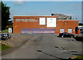
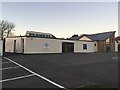
Llantwit Major Leisure Centre
Located in the NE corner of the Llantwit Major Comprehensive School site, http://www.geograph.org.uk/photo/3493370 Ham Lane East.
Image: © Jaggery
Taken: 9 Jul 2011
0.16 miles
9
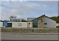
Llantwit Major RFC
The rugby club is on the right. To the left, behind the wall, is the local bowling green.
Image: © Mick Lobb
Taken: 5 Jan 2009
0.16 miles
10
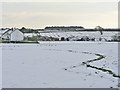
Across the school playing field in winter
The extensive playing fields belong to the local comprehensive school.
Image: © Mick Lobb
Taken: 3 Feb 2009
0.18 miles