IMAGES TAKEN NEAR TO
Sea View Place, LLANTWIT MAJOR, CF61 1TF
Introduction
This page details the photographs taken nearby to Sea View Place, CF61 1TF by members of the Geograph project.
The Geograph project started in 2005 with the aim of publishing, organising and preserving representative images for every square kilometre of Great Britain, Ireland and the Isle of Man.

There are currently over 7.5m images from over14,400 individuals and you can help contribute to the project by visiting https://www.geograph.org.uk
Image Map
Images are licensed for reuse under creativecommons.org/licenses/by-sa/2.0
Notes
- Clicking on the map will re-center to the selected point.
- The higher the marker number, the further away the image location is from the centre of the postcode.
Image Listing (353 Images Found)
Images are licensed for reuse under creativecommons.org/licenses/by-sa/2.0
Image
Details
Distance
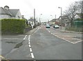
1
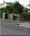
Dark green cabinets on a Llantwit Major corner
Telecoms cabinets on the Stallcourt Avenue side of the Baron's Close corner.
Image: © Jaggery
Taken: 5 Nov 2019
0.05 miles
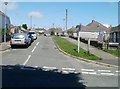
2
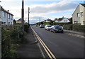
Stallcourt Avenue, Llantwit Major
Looking south from near the Boverton Road junction.
Image: © Jaggery
Taken: 5 Nov 2019
0.06 miles
3
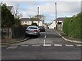
West side of Baron's Close, Llantwit Major
This part of Baron's Close is on the west side of Stallcourt Avenue.
Image: © Jaggery
Taken: 5 Nov 2019
0.06 miles
4
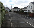
East side of Baron's Close, Llantwit Major
This part of Baron's Close is on the east side of Stallcourt Avenue.
Image: © Jaggery
Taken: 5 Nov 2019
0.07 miles
5
Spitzkop, Llantwit Major
Viewed from Colhugh Street. Spitzkop is a residential cul-de-sac.
One online source suggests that the unusual street name is unique in the UK.
Image: © Jaggery
Taken: 9 Jul 2011
0.07 miles
7
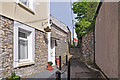
Hidden alley off Colhugh Street, Llantwit Major
This little alley links the older part of town with a post war housing estate.
Image: © Mick Lobb
Taken: 29 Apr 2009
0.10 miles
8
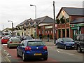
Boverton Road, Llantwit Major
Looking along the busy main shopping street of this small dormitory town, which includes the post office and a small shopping centre.
Image: © Stephen McKay
Taken: 15 Dec 2006
0.10 miles
9
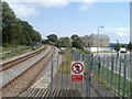
The view from the SE edge of Llantwit Major railway station
The tracks, on the Vale of Glamorgan line, head for Rhoose station, about 10 kilometres away. The road is Le Pouliguen Way, named after the French town twinned with Llantwit Major.
Image: © Jaggery
Taken: 9 Jul 2011
0.10 miles
10
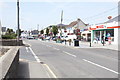
Boverton Road
Running into East Street, this is the main shopping street of Llantwit Major.
Image: © Bill Boaden
Taken: 4 Aug 2018
0.10 miles