IMAGES TAKEN NEAR TO
West Street, LLANTWIT MAJOR, CF61 1SQ
Introduction
This page details the photographs taken nearby to West Street, CF61 1SQ by members of the Geograph project.
The Geograph project started in 2005 with the aim of publishing, organising and preserving representative images for every square kilometre of Great Britain, Ireland and the Isle of Man.

There are currently over 7.5m images from over14,400 individuals and you can help contribute to the project by visiting https://www.geograph.org.uk
Image Map
Images are licensed for reuse under creativecommons.org/licenses/by-sa/2.0
Notes
- Clicking on the map will re-center to the selected point.
- The higher the marker number, the further away the image location is from the centre of the postcode.
Image Listing (322 Images Found)
Images are licensed for reuse under creativecommons.org/licenses/by-sa/2.0
Image
Details
Distance
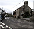
1
Turkey Street, Llantwit Major
One of the quaint old residential streets in the old part of the town.
Image: © Mick Lobb
Taken: 3 Feb 2009
0.01 miles
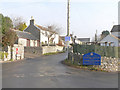
2
Eastern end of Dimlands Road, Llantwit Major
Viewed from the corner of River Walk. Some maps show the road ahead
as College Street but the name sign shows Dimlands Road.
Image: © Jaggery
Taken: 9 Jul 2011
0.03 miles
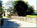
3
Old Malt House, Llantwit Major
Viewed across West Street from the corner of Westhill Street.
Image: © Jaggery
Taken: 3 Apr 2015
0.04 miles
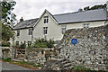
6
College Street
College Street, Llantwit Major, with the blue plaque for Plymouth House.
Image: © Wayland Smith
Taken: 21 Oct 2012
0.04 miles
7
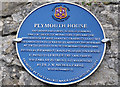
Blue Plaque, Plymouth House - Llantwit Major
Image: © Mick Lobb
Taken: 30 Sep 2009
0.04 miles
8
Ordnance Survey Cut Mark
This OS cut mark can be found on the garage of Plymouth House. It marks a point 39.566m above mean sea level.
Image: © Adrian Dust
Taken: 11 Mar 2018
0.05 miles
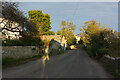
9
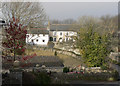
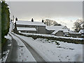
Across a paddock to West Street, Llantwit Major
Image: © Mick Lobb
Taken: 9 Jan 2009
0.05 miles
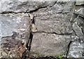
10
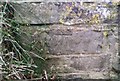
Ordnance Survey Cut Mark
This OS cut mark can be found on the wall NW side of the road. It marks a point 46.004m above mean sea level.
Image: © Adrian Dust
Taken: 11 Mar 2018
0.05 miles