IMAGES TAKEN NEAR TO
Hillhead, LLANTWIT MAJOR, CF61 1SF
Introduction
This page details the photographs taken nearby to Hillhead, CF61 1SF by members of the Geograph project.
The Geograph project started in 2005 with the aim of publishing, organising and preserving representative images for every square kilometre of Great Britain, Ireland and the Isle of Man.

There are currently over 7.5m images from over14,400 individuals and you can help contribute to the project by visiting https://www.geograph.org.uk
Image Map
Images are licensed for reuse under creativecommons.org/licenses/by-sa/2.0
Notes
- Clicking on the map will re-center to the selected point.
- The higher the marker number, the further away the image location is from the centre of the postcode.
Image Listing (337 Images Found)
Images are licensed for reuse under creativecommons.org/licenses/by-sa/2.0
Image
Details
Distance
1
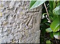
Ordnance Survey Cut Mark
This OS cut mark can be found on the house SW side of the road. It marks a point 43.300m above mean sea level.
Image: © Adrian Dust
Taken: 11 Mar 2018
0.02 miles
2
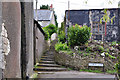
Church Lane and steps to the Gatehouse, Llantwit Major
Image: © Mick Lobb
Taken: 29 Apr 2009
0.02 miles
3
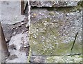
Ordnance Survey Cut Mark
This damaged OS cut mark can be found on the building at the bottom of the steps on Church Lane.
Image: © Adrian Dust
Taken: 11 Mar 2018
0.02 miles
4
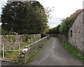
Church Lane towards Burial Lane, Llantwit Major
This part of Church Lane is above Ogney Brook on the left. https://www.geograph.org.uk/photo/6332512
Image: © Jaggery
Taken: 5 Nov 2019
0.02 miles
5
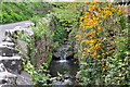
The Ogney Brook on Church Lane, Llantwit Major
Image: © Mick Lobb
Taken: 29 Apr 2009
0.02 miles
6
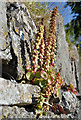
Flowering Navelwort - Llantwit Major
This plant clings to the face of shady walls or rock with its roots deep in their crevices. It is also known as the Wall Pennywort. Here the plant has recently begun to bloom.
Image: © Mick Lobb
Taken: 31 May 2009
0.02 miles
7
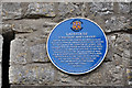
Blue plaque on The Grange Gatehouse, Llantwit Major
Image: © Mick Lobb
Taken: 29 Apr 2009
0.02 miles
8
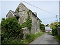
Gatehouse, Llantwit Major
The building was the gatehouse entrance to farm buildings on this site and used to belong to Tewkesbury Abbey in Gloucestershire. For more information see: Image
Image: © Philip Halling
Taken: 14 Jun 2021
0.02 miles
9
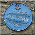
Gatehouse blue plaque
Blue plaque on the wall of the gatehouse in Llantwit Major/Llanilltud Fawr.
Image: © Philip Halling
Taken: 14 Jun 2021
0.02 miles
10
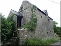
Gatehouse to Tewkesbury Abbey Grange
The blue plaque on the west wall explains that "this 14th Century house afforded entry into a cluster of farm buildings belonging to the Grange of Tewkesbury Abbey. The Grange was an estate also known as West Llantwit or Abbot's Llantwit. After the dissolution of the monasteries it was sold to Edward Stradling and later descended to the Earl of Plymouth. On the south side the dovecote and remnants of the tithe barn are still visible."
Image: © Eirian Evans
Taken: 23 Jun 2021
0.02 miles