1
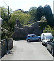
Lane to Methodist Lane, Llantwit Major
Image: © Mick Lobb
Taken: 3 Feb 2009
0.01 miles
2
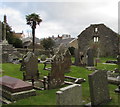
Remains of the Chantry House, Llantwit Major
Badly damaged by a German bomb in August 1940, the remains of the chantry priest's house
are on the south side of St Illtud's churchyard.
Image: © Jaggery
Taken: 9 Jul 2011
0.01 miles
3
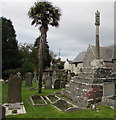
Two Grade II Listed structures in St Illtud's churchyard, Llantwit Major
A restored medieval cross https://www.geograph.org.uk/photo/6332454 is on the left.
The ruins of a chantry priest's house dating from c1500 https://www.geograph.org.uk/photo/6332487 are on the right.
Image: © Jaggery
Taken: 5 Nov 2019
0.01 miles
4
Grade II Listed cross in St Illtud's churchyard, Llantwit Major
Cadw records that the cross is partly medieval, probably 15th century, partly early 20th century. In c1919 the upper part of the shaft and a canopied cross were added to the remains of the medieval base. Grade II Listed in 1982.
Image: © Jaggery
Taken: 5 Nov 2019
0.01 miles
5
Churchyard Cross, Llantwit Major
On the south side of the Church of St. Illtud and about 20m from the south porch. Probably dates from the C15th, but also incorporates a WW1 memorial.
Image: © Eirian Evans
Taken: 23 Jun 2021
0.01 miles
6
Old White Hart
Ancient inn on the triangular market place in Llantwit Major. St Illtud's church is in the background. A church was first founded here in 500AD.
Image: © Colin Smith
Taken: 18 Jul 2009
0.02 miles
7
St. Illtyd's church in Llantwit Major
Really interesting church building https://en.wikipedia.org/wiki/St_Illtyd%27s_Church,_Llantwit_Major
Image: © Jeremy Bolwell
Taken: 24 Sep 2017
0.02 miles
8
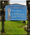
Information board in St Illtud's churchyard, Llantwit Major
Church service times and other information viewed in November 2019 on the approach to this https://www.geograph.org.uk/photo/6332450 church. Welsh/English text on the board includes LLAN ILLTUD FAWR - ILLTUD'S GREAT CHURCH.
Llantwit Major is Llanilltud Fawr in Welsh.
Image: © Jaggery
Taken: 5 Nov 2019
0.02 miles
9
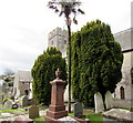
Yews in St Illtud's churchyard, Llantwit Major
A tall, slender exotic tree is between two yews. The European Yew (Taxus baccata) is an evergreen tree often found in churchyards in the UK, Ireland, France and northern parts of Spain.
Image: © Jaggery
Taken: 5 Nov 2019
0.02 miles
10
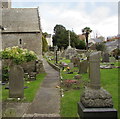
Path through St Illtud's churchyard, Llantwit Major
From Church Lane towards College Street.
Image: © Jaggery
Taken: 5 Nov 2019
0.02 miles


