IMAGES TAKEN NEAR TO
Church Lane, LLANTWIT MAJOR, CF61 1FB
Introduction
This page details the photographs taken nearby to Church Lane, CF61 1FB by members of the Geograph project.
The Geograph project started in 2005 with the aim of publishing, organising and preserving representative images for every square kilometre of Great Britain, Ireland and the Isle of Man.

There are currently over 7.5m images from over14,400 individuals and you can help contribute to the project by visiting https://www.geograph.org.uk
Image Map
Images are licensed for reuse under creativecommons.org/licenses/by-sa/2.0
Notes
- Clicking on the map will re-center to the selected point.
- The higher the marker number, the further away the image location is from the centre of the postcode.
Image Listing (341 Images Found)
Images are licensed for reuse under creativecommons.org/licenses/by-sa/2.0
Image
Details
Distance
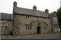
1
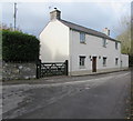
Church House, Church Lane, Llantwit Major
Opposite the west side of St Illtud's Church.
Image: © Jaggery
Taken: 5 Nov 2019
0.00 miles
2
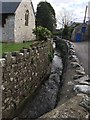
Ogney Brook
The Ogney Brook flows alongside St.Illtyd's Church before joining or becoming the Col-Huw river.
Image: © Alan Hughes
Taken: 16 Dec 2016
0.00 miles
3
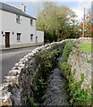
Upstream along Ogney Brook, Church Lane, Llantwit Major
Church House https://www.geograph.org.uk/photo/6332502 is on the left.
Image: © Jaggery
Taken: 5 Nov 2019
0.01 miles
4
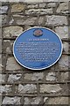
The Old Swan, Llanilltud Fawr
One of the six blue plaques in the town otherwise known as Llantwit Major.
Image: © Natalia A McKenzie
Taken: 5 Jul 2008
0.01 miles
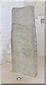
5
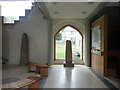
Galilee Chapel, St Illtud's Church
Early medieval stones in St Illtud's Church
Image: © Eirian Evans
Taken: 23 Jun 2021
0.01 miles
6
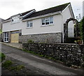
Rock Cottage, Church Lane, Llantwit Major
The typical chocolate-box depiction of a British cottage, usually thatched, is only one type of cottage.
In early 21st century UK usage, a cottage can be anything from a humble shack to a grand mansion.
Image: © Jaggery
Taken: 5 Nov 2019
0.01 miles
8
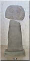
Llantwit Major - St Illtud's Church - Houelt Cross
St Illtud’s is the mother church of the Glamorgan Heritage Coast Parish, overseeing 11 neighbouring churches in the Vale of Glamorgan.
The Houelt Cross, probably mid-late 9th century, is one of the most best examples of a "wheel cross" in Wales.
www.llanilltud.org.uk
Image: © Colin Smith
Taken: 31 Aug 2018
0.02 miles
9
Llantwit Major - St Illtud's Church - Samson Cross
St Illtud’s is the mother church of the Glamorgan Heritage Coast Parish, overseeing 11 neighbouring churches in the Vale of Glamorgan.
The Samson Cross, probably early 10th century, is believed to be dedicated to Saint Illtud.
www.llanilltud.org.uk
Image: © Colin Smith
Taken: 31 Aug 2018
0.02 miles
10
Old Swan Inn, Llanilltud Fawr
The building dates back to the 16th century but it is uncertain when it was first used as an inn.
Image: © Natalia A McKenzie
Taken: 5 Jul 2008
0.02 miles