IMAGES TAKEN NEAR TO
Court Close, LLANTWIT MAJOR, CF61 1FA
Introduction
This page details the photographs taken nearby to Court Close, CF61 1FA by members of the Geograph project.
The Geograph project started in 2005 with the aim of publishing, organising and preserving representative images for every square kilometre of Great Britain, Ireland and the Isle of Man.

There are currently over 7.5m images from over14,400 individuals and you can help contribute to the project by visiting https://www.geograph.org.uk
Image Map
Images are licensed for reuse under creativecommons.org/licenses/by-sa/2.0
Notes
- Clicking on the map will re-center to the selected point.
- The higher the marker number, the further away the image location is from the centre of the postcode.
Image Listing (445 Images Found)
Images are licensed for reuse under creativecommons.org/licenses/by-sa/2.0
Image
Details
Distance
1
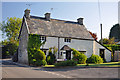
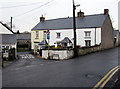
An old stone cottage, 'The Old House' - Llantwit Major
This is an early 17th century, two storey cottage. An extension was added to the south-west in the 18th or early 19th century which is first recorded on the 1840 Tithe Map.
Image: © Mick Lobb
Taken: 31 May 2009
0.03 miles
2
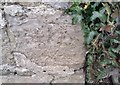
Ordnance Survey Cut Mark
This OS cut mark can be found on the Old House, Llantwit Major Road. It marks a point 161.1ft above mean sea level.
Image: © Adrian Dust
Taken: 11 Mar 2018
0.03 miles
3
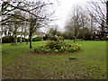
Diamond Jubilee field, Llantwit Major
The Llantwit Major Town Council notice on the entrance gate on the east side of High Street is dated 2012.
It states that this space has been protected forever for your community to celebrate the Diamond Jubilee (of Queen Elizabeth II).
Image: © Jaggery
Taken: 3 Apr 2015
0.03 miles
4
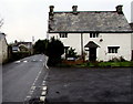
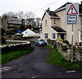
High Street speed bumps near The Old House, Llantwit Major
The Old House http://www.geograph.org.uk/photo/1331223 is on the corner of Court Close.
Image: © Jaggery
Taken: 3 Apr 2015
0.04 miles
5
Turkey Street, Llantwit Major
Viewed across High Street. A one-way system is in force along narrow Turkey Street.
Image: © Jaggery
Taken: 3 Apr 2015
0.05 miles
6
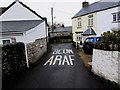
Welsh and English sign on Turkey Street, Llantwit Major
Bilingual sign painted on Turkey Street on the approach to a bend.
Image: © Jaggery
Taken: 3 Apr 2015
0.05 miles
7
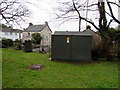
Court House electricity substation, Llantwit Major
The Western Power Distribution electricity substation identifier is COURT HOUSE S/S 562970.
Image: © Jaggery
Taken: 3 Apr 2015
0.06 miles
8
Ford sign, Turkey Street, Llantwit Major
On the eastern approach to this http://www.geograph.org.uk/photo/4413153 ford through Ogney Brook. Rhyd is Welsh for ford.
Image: © Jaggery
Taken: 3 Apr 2015
0.07 miles
9
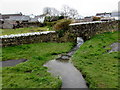
Ogney Brook flows across a ford, Llantwit Major
There is a grassy and watery gap of several metres between the two sections of roadway.
http://www.geograph.org.uk/photo/4413153 to a view from the road.
Image: © Jaggery
Taken: 3 Apr 2015
0.07 miles
10
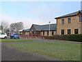
WVICC, Llantwit Major
The Western Vale Integrated Children's Centre caters for four core themes – early years education, childcare, open access play, and training and community development and provides a wide variety of facilities and courses for various groups and organisations.
These include Sunshine Group, Stay and Play, Parent and Toddler, Childminders' Support Group, Credit Union, Clap, Tap and Rhyme, Fruit and Veg Community Co-operative.
Image: © Mick Lobb
Taken: 9 Jan 2009
0.07 miles