IMAGES TAKEN NEAR TO
Bonvilston, CARDIFF, CF5 6TS
Introduction
This page details the photographs taken nearby to CF5 6TS by members of the Geograph project.
The Geograph project started in 2005 with the aim of publishing, organising and preserving representative images for every square kilometre of Great Britain, Ireland and the Isle of Man.

There are currently over 7.5m images from over14,400 individuals and you can help contribute to the project by visiting https://www.geograph.org.uk
Image Map
Images are licensed for reuse under creativecommons.org/licenses/by-sa/2.0
Notes
- Clicking on the map will re-center to the selected point.
- The higher the marker number, the further away the image location is from the centre of the postcode.
Image Listing (7 Images Found)
Images are licensed for reuse under creativecommons.org/licenses/by-sa/2.0
Image
Details
Distance
1
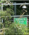
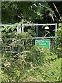
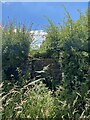
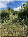
Brambles, a sign - and a cowbell!
Marked on OS maps as a public footpath, someone rightly or wrongly thinks otherwise and has attached a novel warning device.
See also Image] of which this image is a detail.
Image: © Alan Hughes
Taken: 7 Jul 2022
0.02 miles
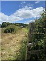
6
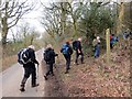
Ger / Near Ffarm Ty Draw Farm
Cerddwyr yn gadael yr heol i ymuno a llwybr cyhoeddus ger Ffarm Ty Draw.
Walkers leaving a minor road to join a public footpath near Ty Draw Farm (trans. furthest house)
Image: © Alan Richards
Taken: 15 Mar 2015
0.15 miles