IMAGES TAKEN NEAR TO
St. Nicholas, CARDIFF, CF5 6SJ
Introduction
This page details the photographs taken nearby to CF5 6SJ by members of the Geograph project.
The Geograph project started in 2005 with the aim of publishing, organising and preserving representative images for every square kilometre of Great Britain, Ireland and the Isle of Man.

There are currently over 7.5m images from over14,400 individuals and you can help contribute to the project by visiting https://www.geograph.org.uk
Image Map
Images are licensed for reuse under creativecommons.org/licenses/by-sa/2.0
Notes
- Clicking on the map will re-center to the selected point.
- The higher the marker number, the further away the image location is from the centre of the postcode.
Image Listing (12 Images Found)
Images are licensed for reuse under creativecommons.org/licenses/by-sa/2.0
Image
Details
Distance
1
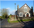
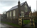
Trehill Presbyterian Church, St Nicholas
Located alongside a lane 50 metres from the north side of the A48.
Built as a Calvinistic Methodist church, now Presbyterian Church of Wales.
TREHILL 1870 is shown in black lettering on a white background above the central window.
Image: © Jaggery
Taken: 27 Jan 2012
0.07 miles
2
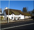
Trehill Cottage, St Nicholas
The thatched cottage on the north side of the A48 was originally a cottage for farm labourers attached to Trehill Farm. It has since been substantially renovated and extended.
Image: © Jaggery
Taken: 27 Jan 2012
0.07 miles
3
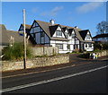
The Retreat, St Nicholas
House on the north side of the A48 in the western part of the village of St Nicholas, Vale of Glamorgan.
Image: © Jaggery
Taken: 27 Jan 2012
0.07 miles
4
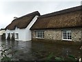
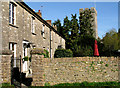
Cottage - St.Nicholas
Quaint cottage at Trehill on the outskirts of St.Nicholas.
Image: © Alan Hughes
Taken: 4 Jan 2016
0.07 miles
5
Soar Chapel, Trehill
Soar Presbyterian Chapel, Trehill, St.Nicholas.
Image: © Alan Hughes
Taken: 4 Jan 2016
0.08 miles
6
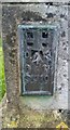
Ordnance Survey Flush Bracket (S1310)
This OS Flush Bracket can be found on the east angle of the Presbyterian Church. It marks a point 116.695m above mean sea level.
Image: © Adrian Dust
Taken: 30 Oct 2021
0.09 miles
8
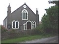
Trehill Presbyterian Church of Wales, St Nicholas, Vale of Glamorgan
Image: © John Lord
Taken: 9 Sep 2008
0.11 miles
9
Church Row cottages and church, St Nicholas
Image: © Tony Hodge
Taken: 3 Nov 2006
0.16 miles
10
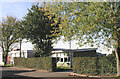
St Nicholas Church in Wales Primary School
Image: © Tony Hodge
Taken: 3 Nov 2006
0.16 miles