IMAGES TAKEN NEAR TO
Pound Lane, CARDIFF, CF5 6PL
Introduction
This page details the photographs taken nearby to Pound Lane, CF5 6PL by members of the Geograph project.
The Geograph project started in 2005 with the aim of publishing, organising and preserving representative images for every square kilometre of Great Britain, Ireland and the Isle of Man.

There are currently over 7.5m images from over14,400 individuals and you can help contribute to the project by visiting https://www.geograph.org.uk
Image Map
Images are licensed for reuse under creativecommons.org/licenses/by-sa/2.0
Notes
- Clicking on the map will re-center to the selected point.
- The higher the marker number, the further away the image location is from the centre of the postcode.
Image Listing (26 Images Found)
Images are licensed for reuse under creativecommons.org/licenses/by-sa/2.0
Image
Details
Distance
1
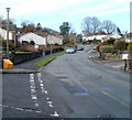
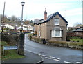
Walston Road heads towards Wallston, Wenvoe
The view to the NW from the corner of Church Rise. http://www.geograph.org.uk/photo/2168361
Curiously, the road and the destination are spelt differently.
Image: © Jaggery
Taken: 19 Nov 2010
0.09 miles
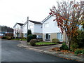
2
Wenvoe Close, Wenvoe
Houses on the north side of the close, viewed from the far end, on the path to Wenvoe Library. http://www.geograph.org.uk/photo/2167708
Image: © Jaggery
Taken: 19 Nov 2010
0.09 miles
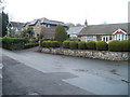
3
Corner of Church Rise and Walston Road, Wenvoe
Church Rise is on the left. Walston Road is heading for the area of NW Wenvoe that is spelt Wallston (with two els ...)
Image: © Jaggery
Taken: 19 Nov 2010
0.11 miles
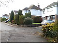
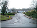
4
Springfield Close, Wenvoe
Houses on the north side of a cul-de-sac connecting with Old Port Road.
Image: © Jaggery
Taken: 19 Nov 2010
0.15 miles
5
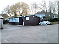
Wenvoe Library
Located in the Terrapin Building at the back of the Community Centre http://www.geograph.org.uk/photo/2167700 on the west side of Old Port Road. The library is part of the Vale of Glamorgan Library and Information Service.
Image: © Jaggery
Taken: 19 Nov 2010
0.15 miles
6
Jelly mould chimney pot, Walston Road, Wenvoe
I don't know if there is a technical term for this distinctive style of chimney pot, but 'jelly mould' seems as good as any. Viewed from the corner of Clos Llanfair.
Image: © Jaggery
Taken: 19 Nov 2010
0.17 miles
7
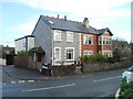
Walston Road, Wenvoe
Houses on the north side of Walston Road, facing St Mary's Church. http://www.geograph.org.uk/photo/2168303
Image: © Jaggery
Taken: 19 Nov 2010
0.17 miles
8
Southern arm of Gwenfo Drive, Wenvoe
Gwenfo Drive follows a course similar to an inverted U on the west side of Old Port Road. This view is along its southern arm, from the corner of Old Port Road. http://www.geograph.org.uk/photo/2167682 to houses along its northern arm.
Image: © Jaggery
Taken: 19 Nov 2010
0.19 miles
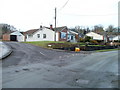
9
Corner of Old Port Road and Old Market, Wenvoe
The houses on the corner are next to the village store and post office, http://www.geograph.org.uk/photo/2167952 just out of shot on the left, on the other side of a street named Old Market.
Image: © Jaggery
Taken: 19 Nov 2010
0.21 miles
10
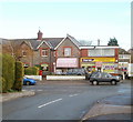
Wenvoe Post Office and stores
The post office is inside Springfield Stores, on the corner of Old Port Road and a street named Old Market, viewed along Springfield Close.
Image: © Jaggery
Taken: 19 Nov 2010
0.21 miles