IMAGES TAKEN NEAR TO
Peterston-Super-Ely, CARDIFF, CF5 6LJ
Introduction
This page details the photographs taken nearby to CF5 6LJ by members of the Geograph project.
The Geograph project started in 2005 with the aim of publishing, organising and preserving representative images for every square kilometre of Great Britain, Ireland and the Isle of Man.

There are currently over 7.5m images from over14,400 individuals and you can help contribute to the project by visiting https://www.geograph.org.uk
Image Map
Images are licensed for reuse under creativecommons.org/licenses/by-sa/2.0
Notes
- Clicking on the map will re-center to the selected point.
- The higher the marker number, the further away the image location is from the centre of the postcode.
Image Listing (31 Images Found)
Images are licensed for reuse under creativecommons.org/licenses/by-sa/2.0
Image
Details
Distance
1
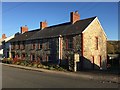
Stone Cottages
Distinctive stone housing, with brick window features, at Peterston-super-Ely.
Image: © Alan Hughes
Taken: 25 Nov 2016
0.03 miles
2
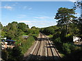
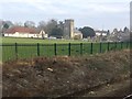
South Wales Main Line at Peterston-super-Ely
Image: © Gareth James
Taken: 25 Sep 2010
0.04 miles
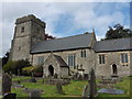
4
Eglwys Llanbedr y Fro / Peterston Super Ely Church
Eglwys Llanbedr y Fro.
St Peter's Church at Peterstone Super Ely.
Image: © Alan Richards
Taken: 12 Sep 2010
0.04 miles
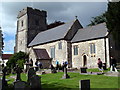
5
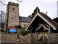
Church, Peterston-super-Ely
St Peters Church, Peterston-super-Ely.
Image: © Stuart Wilding
Taken: 11 Mar 2007
0.05 miles
6
View from a Cardiff-Swansea train - Peterston-super-Ely
Image: © Nigel Thompson
Taken: 27 Jan 2017
0.05 miles
7
St.Peter's Church
St.Peter's Church, Peterston-super-Ely.
Image: © Alan Hughes
Taken: 25 Nov 2016
0.05 miles
8
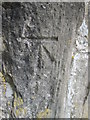
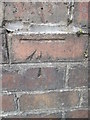
Ordnance Survey Cut Mark
This OS cut mark can be found on the SW face of St Peter's Church. It marks a point 27.146m above mean sea level.
Image: © Adrian Dust
Taken: 9 Apr 2016
0.05 miles
9
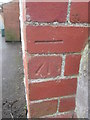
Ordnance Survey Cut Mark
This OS cut mark can be found on The Old Manse. On the SE side of the road. It marks a point 31.675m above mean sea level.
Image: © Adrian Dust
Taken: 9 Apr 2016
0.07 miles
10
Ordnance Survey Cut Mark
This OS cut mark can be found on the NW parapet of the railway bridge. It marks a point 27.847m above mean sea level.
Image: © Adrian Dust
Taken: 9 Apr 2016
0.07 miles