IMAGES TAKEN NEAR TO
St. George'S-Super-Ely, CARDIFF, CF5 6ER
Introduction
This page details the photographs taken nearby to CF5 6ER by members of the Geograph project.
The Geograph project started in 2005 with the aim of publishing, organising and preserving representative images for every square kilometre of Great Britain, Ireland and the Isle of Man.

There are currently over 7.5m images from over14,400 individuals and you can help contribute to the project by visiting https://www.geograph.org.uk
Image Map
Images are licensed for reuse under creativecommons.org/licenses/by-sa/2.0
Notes
- Clicking on the map will re-center to the selected point.
- The higher the marker number, the further away the image location is from the centre of the postcode.
Image Listing (29 Images Found)
Images are licensed for reuse under creativecommons.org/licenses/by-sa/2.0
Image
Details
Distance
1
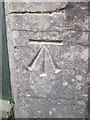
Ordnance Survey Cut Mark
This OS cut mark can be found on the west face of St George's Church. It marks a point 20.153m above mean sea level.
Image: © Adrian Dust
Taken: 9 Apr 2016
0.02 miles
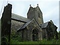
2
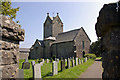
St George's Church
Parish Church of St George, St.George's-super-Ely.
Image: © Alan Hughes
Taken: 6 Nov 2018
0.03 miles
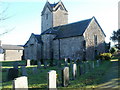
3
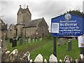
Parish Church of St George, St. Georges-super-Ely
This is a Grade II listed building and is one of the smallest cruciform churches in Wales. The church was restored in 1838, 1857 and again in 1886.
Sadly, the church is no longer in regular use, though the burial ground is still being used judging by the dates of recent internments.
Image: © Colin Cheesman
Taken: 18 Jun 2021
0.03 miles
4
St George's Church
Grade 2* listed church in the hamlet of St George's-super-Ely, Vale of Glamorgan.
The church is Norman (with a possibly Early Christian foundation). It was altered and restored in 1838.
Image: © Jaggery
Taken: 15 Nov 2010
0.04 miles
5
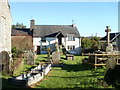
Hen Ysgol, St George's-super-Ely
Viewed across the eastern side of St George's http://www.geograph.org.uk/photo/2164226 churchyard. Steps lead up to a doorway on the first floor. Hen Ysgol is Welsh for 'old school'. Now a private dwelling, the building was formerly a school, founded in the early 19th century for children of farm workers and tenants of the Traherne family.
Image: © Jaggery
Taken: 15 Nov 2010
0.04 miles
6

Church Cottage, St George's
Grade 2 listed building now divided into two dwellings. The stone-built cottage, dating from about 1860, is on the west side of the Grade 2* listed church. http://www.geograph.org.uk/photo/2164226
Image: © Jaggery
Taken: 15 Nov 2010
0.04 miles
7
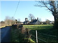
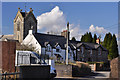
Two listed buildings, St George's-super-Ely
A view from the west.
Centre left is the Grade 2* listed St George's Church. http://www.geograph.org.uk/photo/2164226
Centre right is the Grade 2 listed Church Cottage. http://www.geograph.org.uk/photo/2164240
Image: © Jaggery
Taken: 15 Nov 2010
0.04 miles
8
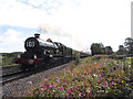
Steam charter train at St George's
The Railway Touring Company's Pembroke Coast Express, from Bristol to Pembroke Dock, passes the Vale of Glamorgan village of St. George's with ex-Great Western Castle-class locomotive No. 5029 Nunney Castle in charge.
Image: © Gareth James
Taken: 31 Aug 2014
0.05 miles