IMAGES TAKEN NEAR TO
Clos Llanfair, CARDIFF, CF5 6DJ
Introduction
This page details the photographs taken nearby to Clos Llanfair, CF5 6DJ by members of the Geograph project.
The Geograph project started in 2005 with the aim of publishing, organising and preserving representative images for every square kilometre of Great Britain, Ireland and the Isle of Man.

There are currently over 7.5m images from over14,400 individuals and you can help contribute to the project by visiting https://www.geograph.org.uk
Image Map
Images are licensed for reuse under creativecommons.org/licenses/by-sa/2.0
Notes
- Clicking on the map will re-center to the selected point.
- The higher the marker number, the further away the image location is from the centre of the postcode.
Image Listing (32 Images Found)
Images are licensed for reuse under creativecommons.org/licenses/by-sa/2.0
Image
Details
Distance
1
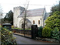
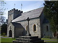
St Mary's Church, Wenvoe
Grade II* listed church, believed to date from the 13th century. There was major restoration work in 1869. Its full name, shown on the board outside, is
Diocese of Llandaff, St Mary's Parish Church, Wenvoe.
Located on the west side of Old Port Road and the south side of Walston Road.
Image: © Jaggery
Taken: 19 Nov 2010
0.06 miles
2
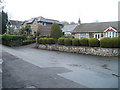
Walston Road, Wenvoe
Houses on the north side of Walston Road, facing St Mary's Church. http://www.geograph.org.uk/photo/2168303
Image: © Jaggery
Taken: 19 Nov 2010
0.07 miles
3
Jelly mould chimney pot, Walston Road, Wenvoe
I don't know if there is a technical term for this distinctive style of chimney pot, but 'jelly mould' seems as good as any. Viewed from the corner of Clos Llanfair.
Image: © Jaggery
Taken: 19 Nov 2010
0.07 miles
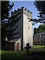
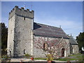
8
St.Mary's Church, Wenvoe
Parish church of St.Mary, Wenvoe.
Image: © Alan Hughes
Taken: 4 Apr 2016
0.09 miles
9
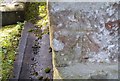
Ordnance Survey Cut Mark
This OS cut mark can be found on the NE face of St Mary's Church. It marks a point 52.855m above mean sea level.
Image: © Adrian Dust
Taken: 16 Mar 2018
0.09 miles
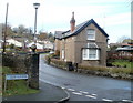
10
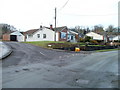
Corner of Church Rise and Walston Road, Wenvoe
Church Rise is on the left. Walston Road is heading for the area of NW Wenvoe that is spelt Wallston (with two els ...)
Image: © Jaggery
Taken: 19 Nov 2010
0.09 miles