1
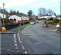
Corner of Church Rise and Walston Road, Wenvoe
Church Rise is on the left. Walston Road is heading for the area of NW Wenvoe that is spelt Wallston (with two els ...)
Image: © Jaggery
Taken: 19 Nov 2010
0.03 miles
2
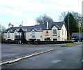
Jelly mould chimney pot, Walston Road, Wenvoe
I don't know if there is a technical term for this distinctive style of chimney pot, but 'jelly mould' seems as good as any. Viewed from the corner of Clos Llanfair.
Image: © Jaggery
Taken: 19 Nov 2010
0.04 miles
3
Walston Road, Wenvoe
Houses on the north side of Walston Road, facing St Mary's Church. http://www.geograph.org.uk/photo/2168303
Image: © Jaggery
Taken: 19 Nov 2010
0.04 miles
4
Walston Road heads towards Wallston, Wenvoe
The view to the NW from the corner of Church Rise. http://www.geograph.org.uk/photo/2168361
Curiously, the road and the destination are spelt differently.
Image: © Jaggery
Taken: 19 Nov 2010
0.08 miles
5
Wenvoe Close, Wenvoe
Houses on the north side of the close, viewed from the far end, on the path to Wenvoe Library. http://www.geograph.org.uk/photo/2167708
Image: © Jaggery
Taken: 19 Nov 2010
0.08 miles
6
Springfield Close, Wenvoe
Houses on the north side of a cul-de-sac connecting with Old Port Road.
Image: © Jaggery
Taken: 19 Nov 2010
0.09 miles
7
Wenvoe Library
Located in the Terrapin Building at the back of the Community Centre http://www.geograph.org.uk/photo/2167700 on the west side of Old Port Road. The library is part of the Vale of Glamorgan Library and Information Service.
Image: © Jaggery
Taken: 19 Nov 2010
0.09 miles
8
St.Mary's Church, Wenvoe
Parish church of St.Mary, Wenvoe.
Image: © Alan Hughes
Taken: 4 Apr 2016
0.10 miles
9
Ordnance Survey Cut Mark
This OS cut mark can be found on the NE face of St Mary's Church. It marks a point 52.855m above mean sea level.
Image: © Adrian Dust
Taken: 16 Mar 2018
0.10 miles
10
The Wenvoe Arms viewed from the NE
Village pub dating back to the late 18th century. It is located at 18 Old Port Road, Wenvoe, viewed here from the eastern side of Springfield Close.
Image: © Jaggery
Taken: 19 Nov 2010
0.10 miles


