IMAGES TAKEN NEAR TO
CF4 9DL
Introduction
This page details the photographs taken nearby to CF4 9DL by members of the Geograph project.
The Geograph project started in 2005 with the aim of publishing, organising and preserving representative images for every square kilometre of Great Britain, Ireland and the Isle of Man.

There are currently over 7.5m images from over14,400 individuals and you can help contribute to the project by visiting https://www.geograph.org.uk
Image Map
Images are licensed for reuse under creativecommons.org/licenses/by-sa/2.0
Notes
- Clicking on the map will re-center to the selected point.
- The higher the marker number, the further away the image location is from the centre of the postcode.
Image Listing (9 Images Found)
Images are licensed for reuse under creativecommons.org/licenses/by-sa/2.0
Image
Details
Distance
6
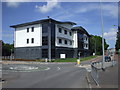
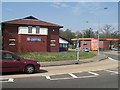
North Cardiff Medical Centre
The previous building Image, only a few years old, was destroyed by fire, the result of a combination of vandalism and somewhat unsuitable design. The vandals set fire to a bin standing against the wall of the building, the flames soon reached its rather low eaves, and from then on the result was inevitable.
Image: © John Lord
Taken: 12 Jun 2010
0.22 miles
8
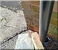
Ordnance Survey Cut Mark
This OS cut mark can be found on No39 Wolfs Castle Avenue. It marks a point 63.258m above mean sea level.
Image: © Adrian Dust
Taken: 26 Feb 2024
0.24 miles