
IMAGES TAKEN NEAR TO
Nixonville, MERTHYR TYDFIL, CF48 4RF
Introduction
This page details the photographs taken nearby to Nixonville, CF48 4RF by members of the Geograph project.
The Geograph project started in 2005 with the aim of publishing, organising and preserving representative images for every square kilometre of Great Britain, Ireland and the Isle of Man.

There are currently over 7.5m images from over14,400 individuals and you can help contribute to the project by visiting https://www.geograph.org.uk
Image Map
Images are licensed for reuse under creativecommons.org/licenses/by-sa/2.0
Notes
- Clicking on the map will re-center to the selected point.
- The higher the marker number, the further away the image location is from the centre of the postcode.
Image Listing (118 Images Found)
Images are licensed for reuse under creativecommons.org/licenses/by-sa/2.0
Image
Details
Distance
1
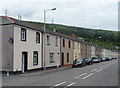
Long row of houses, Nixonville, Merthyr Vale
There are 24 houses in this row in Nixonville (the B4285).
Image: © Jaggery
Taken: 5 Jul 2012
0.05 miles
2
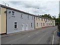
Houses near the northern end of Nixonville, Merthyr Vale
Looking north in the direction of the River Taff bridge and the boundary of Aberfan.
Image: © Jaggery
Taken: 5 Jul 2012
0.05 miles
3
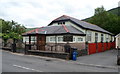
St Benedict's RC Church, Merthyr Vale
St Benedict's Roman Catholic Church was built in 1932, on the east side of Nixonville (the B4285).
Image: © Jaggery
Taken: 5 Jul 2012
0.05 miles
4
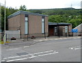
Merthyr Vale Baptist Church, Nixonville
Located in Nixonville (the B4285). The church was built in 1974 for the merged congregations of Zion and Calfaria chapels.
Image: © Jaggery
Taken: 5 Jul 2012
0.06 miles

6

Church of St Mary and Holy Innocents, Merthyr Vale
The Church in Wales church, located between Nixonville (B4285) and the River Taff, was built in 1974. It replaced an earlier church dating from 1926.
Image: © Jaggery
Taken: 5 Jul 2012
0.08 miles
7
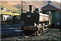
9600 at Merthyr Vale Colliery ? 1969
This is one of a relatively small number of former British Railways locomotives that found their way into further service with the National Coal Board. It is one of the characteristic Great Western Railway pannier tank locos, and was built in 1945. It was withdrawn in 1973 and sold for preservation and is currently (2020) part of the collection at Tyseley Locomotive Works.
Image: © Alan Murray-Rust
Taken: 28 Nov 1969
0.09 miles
8
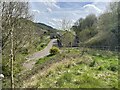
Aberfan railway station (site), Mid Glamorgan
Opened in 1886 jointly by the Great Western Railway and the Rhymney Railway on the line from Quakers Yard (High Level) to Merthyr, this station closed to passengers in 1951 and completely in 1954.
View south from the former bridge (now filled in and embanked) over the tracks towards Pontygwaith and Quakers Yard. The road next to the houses is on the course of the railway which had parallel platforms on either side. The station building was on the immediate far left of the image. The railings on the right mark the course of the footpath down to the northbound platform. The site was redeveloped for housing around 2016.
For more information, see http://www.disused-stations.org.uk/a/aberfan/index.shtml.
Image: © Nigel Thompson
Taken: 12 Apr 2024
0.10 miles
9
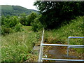
Site of Aberfan railway station
Viewed from the south side of a hairpin bend. http://www.geograph.org.uk/photo/3343014 Grass now grows where once stood Aberfan railway station, which closed in 1951. The nearest station is now in Merthyr Vale. http://www.geograph.org.uk/photo/3024730
Image: © Jaggery
Taken: 5 Jul 2012
0.11 miles
10

Gordon Lenox Constitutional Club
Nixonville, Merthyr Vale.
Image: © Ian S
Taken: 26 May 2014
0.11 miles