IMAGES TAKEN NEAR TO
Station Hill, MERTHYR TYDFIL, CF48 4PR
Introduction
This page details the photographs taken nearby to Station Hill, CF48 4PR by members of the Geograph project.
The Geograph project started in 2005 with the aim of publishing, organising and preserving representative images for every square kilometre of Great Britain, Ireland and the Isle of Man.

There are currently over 7.5m images from over14,400 individuals and you can help contribute to the project by visiting https://www.geograph.org.uk
Image Map
Images are licensed for reuse under creativecommons.org/licenses/by-sa/2.0
Notes
- Clicking on the map will re-center to the selected point.
- The higher the marker number, the further away the image location is from the centre of the postcode.
Image Listing (101 Images Found)
Images are licensed for reuse under creativecommons.org/licenses/by-sa/2.0
Image
Details
Distance
1
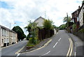
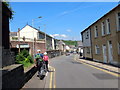
Junction for Station Hill, Aberfan
Partly hidden by vegetation, a sign showing Cemetery points right towards Station Hill, which no longer leads up to a station. Aberfan railway station closed in 1951. Viewed from Aberfan Road which becomes Aberfan Crescent on the left, beyond the junction.
Image: © Jaggery
Taken: 5 Jul 2012
0.01 miles
2
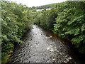
River Taff downstream from the B4285 bridge between Merthyr Vale and Aberfan
Merthyr Vale is on the left side of the river, Aberfan is on the right.
There is a weir http://www.geograph.org.uk/photo/3025941 about 90 metres behind the camera.
Image: © Jaggery
Taken: 5 Jul 2012
0.02 miles
3
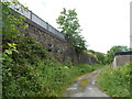
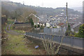
A former railway embankment, Aberfan
Viewed from near the right side http://www.geograph.org.uk/photo/3343015 of a hairpin bend in Station Hill. The stone wall supports the embankment which formerly carried railway lines about 100 metres north of Aberfan railway station, which closed in 1951.
Image: © Jaggery
Taken: 5 Jul 2012
0.02 miles
4
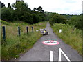
No motorbikes allowed on the Taff Trail, Aberfan
A boulder reinforces the message in the sign on the path surface.
Image: © Jaggery
Taken: 5 Jul 2012
0.03 miles
5
Cilgant Aberfan / Aberfan Crescent
Cerddwyr yn cyrraedd pentre Aberfan.
Walkers arriving at Aberfan village (confluence of the Fan [peak] stream).
Image: © Alan Richards
Taken: 29 May 2016
0.03 miles
6
Site of Aberfan Station
In common with many of the South Wales valleys, Taff Vale had two railways running through it. This over-provision was actively encouraged by Victorian colliery owners who were keen to encourage competition and thus keep freight rates low. After the Second World War, with both the railways and the coal industry nationalised, this situation was no longer tenable and wherever possible services were concentrated on one line. With the Taff Vale main line just a short distance further east, the line that passed here closed to passengers in 1951 and freight in 1954.
Image: © Stephen McKay
Taken: 19 Mar 2013
0.04 miles
7
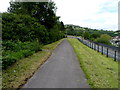
Taff Trail footpath and cycleway, Aberfan
This location is near the site of Aberfan railway station which closed in 1951.
Image: © Jaggery
Taken: 5 Jul 2012
0.04 miles
8
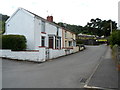
Houses near the entrance to Aberfan cemetery
The street name sign alongside a house wall shows PERTHYGLEISION BRIDGE.
Image: © Jaggery
Taken: 5 Jul 2012
0.05 miles
9
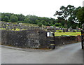
Entrance to Aberfan Cemetery
The cemetery is located on high ground in the SW corner of the village.
Image: © Jaggery
Taken: 5 Jul 2012
0.05 miles
10
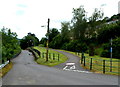
Road, footpath and cycleway, Aberfan
The road on the left descends towards a hairpin bend. www.geograph.org.uk/photo/3343014
The footpath on the right is also a cycleway, for bicycles only. Motorbikes are banned
from using the path by a circular red-edged sign on the path's surface.
Image: © Jaggery
Taken: 5 Jul 2012
0.05 miles