IMAGES TAKEN NEAR TO
Morgan Jones Square, MERTHYR TYDFIL, CF48 4NF
Introduction
This page details the photographs taken nearby to Morgan Jones Square, CF48 4NF by members of the Geograph project.
The Geograph project started in 2005 with the aim of publishing, organising and preserving representative images for every square kilometre of Great Britain, Ireland and the Isle of Man.

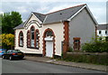
There are currently over 7.5m images from over14,400 individuals and you can help contribute to the project by visiting https://www.geograph.org.uk
Image Map
Images are licensed for reuse under creativecommons.org/licenses/by-sa/2.0
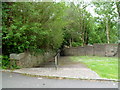
Notes
- Clicking on the map will re-center to the selected point.
- The higher the marker number, the further away the image location is from the centre of the postcode.
Image Listing (152 Images Found)
Images are licensed for reuse under creativecommons.org/licenses/by-sa/2.0
Image
Details
Distance
1
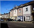
Industrial Terrace, Troedyrhiw
Viewed across the A4054 Cardiff Road.
Image: © Jaggery
Taken: 25 Feb 2019
0.03 miles
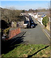
2
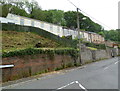
Chapel Street houses, Troedyrhiw
These houses on the east side of Chapel Street are set several metres above the roadway.
Image: © Jaggery
Taken: 13 Jun 2012
0.04 miles
3
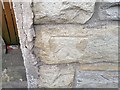
Ordnance Survey Cut Mark
This OS cut mark can be found on No43 Cardiff Road. It marks a point 147.791m above mean sea level.
Image: © Adrian Dust
Taken: 14 Apr 2018
0.05 miles
4
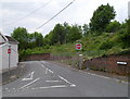
Low bridge 120 yards, Cardiff Road, Troedyrhiw
Drivers of high vehicles are given advance warning of the 14' 9" headroom bridge
over Bridge Street near Troedyrhiw railway station. The text is also in Welsh.
Image: © Jaggery
Taken: 25 Feb 2019
0.06 miles
5
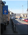
Free Library, Troedyrhiw
The current (June 2012) status of this building on Tyntaldwyn Road is unclear. It is not part of Merthyr Tydfil County Borough Council's library service. Troedyrhiw is served by their mobile library service.
Image: © Jaggery
Taken: 13 Jun 2012
0.06 miles
6
One-way system, Troedyrhiw
Viewed from Chapel Street. A one-way system operates along School Road (ahead) and Tyntaldwyn Road on the left.
Image: © Jaggery
Taken: 13 Jun 2012
0.06 miles
7
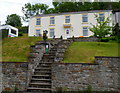
Steps up to Hen Dy Mawr, Troedyrhiw
Formerly two Chapel Street houses now converted into one house.
Hen Dy Mawr is Welsh for big old house.
Image: © Jaggery
Taken: 13 Jun 2012
0.06 miles
8
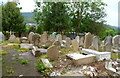
Saron graveyard, Troedyrhiw
Viewed through a locked gate. Located on the corner of Chapel Street and Tyntaldwyn Road, this was formerly the burial ground on the north side of Saron chapel. The chapel was opened in 1835, rebuilt in 1852. The chapel closed in 1983 and was demolished in 1990.
Image: © Jaggery
Taken: 13 Jun 2012
0.06 miles
9
Short cut from Chapel Street to Cardiff Road, Troedyrhiw
Steps descend from the west side of Chapel Street, past the perimeter wall of Saron graveyard. http://www.geograph.org.uk/photo/2992465
Image: © Jaggery
Taken: 13 Jun 2012
0.06 miles
10
Wyndham Street, Troedyrhiw
Viewed from the edge of the A4054 Cardiff Road looking towards Bridge Street.
Image: © Jaggery
Taken: 25 Feb 2019
0.07 miles