IMAGES TAKEN NEAR TO
Merthyr Tydfil Industrial Park, MERTHYR TYDFIL, CF48 4DR
Introduction
This page details the photographs taken nearby to Merthyr Tydfil Industrial Park, CF48 4DR by members of the Geograph project.
The Geograph project started in 2005 with the aim of publishing, organising and preserving representative images for every square kilometre of Great Britain, Ireland and the Isle of Man.

There are currently over 7.5m images from over14,400 individuals and you can help contribute to the project by visiting https://www.geograph.org.uk
Image Map
Images are licensed for reuse under creativecommons.org/licenses/by-sa/2.0
Notes
- Clicking on the map will re-center to the selected point.
- The higher the marker number, the further away the image location is from the centre of the postcode.
Image Listing (48 Images Found)
Images are licensed for reuse under creativecommons.org/licenses/by-sa/2.0
Image
Details
Distance
1
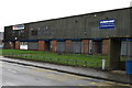
Edmundson Electrical in Pentrebach
Edmundson Electrical on the left is in Unit 13, Merthyr Tydfil Industrial Park
in Pentrebach, viewed across the A4054. A K Cash n Carry is on the right.
Image: © Jaggery
Taken: 8 Mar 2019
0.07 miles
2
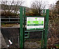
No Fly-Tipping notice in Pentrebach
Facing Duffryn Road near the corner of the A4054, the Merthyr Tydfil
County Borough Council notice in English and Welsh is at the edge of a brook.
Maximum fine £50,000 and/or imprisonment.
Image: © Jaggery
Taken: 8 Mar 2019
0.10 miles
3
Old Duffryn direction sign, Pentrebach
The bilingual sign shows that Old Duffryn is Hen Ddyfryn in Welsh.
Image: © Jaggery
Taken: 8 Mar 2019
0.10 miles
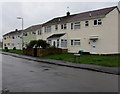
4
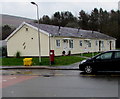
Row of bungalows, Rhydfach, Pentrebach
Viewed across Duffryn Road. Originally, bungalow was used in English for a lightly-built house, with a veranda and one storey. In current UK usage it is a convenient word for any one-storey dwelling.
Image: © Jaggery
Taken: 8 Mar 2019
0.11 miles
5
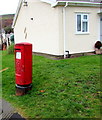
Queen Elizabeth II pillarbox, Duffryn Road, Pentrebach
Located here. https://www.geograph.org.uk/photo/6083101
Image: © Jaggery
Taken: 8 Mar 2019
0.11 miles
6
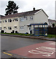
Blue bus shelter, Duffryn Road, Pentrebach
This stop near the A4054 junction is for buses to Merthyr Tydfil bus station.
Image: © Jaggery
Taken: 8 Mar 2019
0.12 miles
7
Rhydfach houses, Pentrebach
Viewed across Duffryn Road. The Rhydfach name sign is on the right.
Image: © Jaggery
Taken: 8 Mar 2019
0.12 miles
8
Rhydfach bungalows, Pentrebach
Viewed from the A4054. Originally, bungalow was used in English for a lightly-built house, with a veranda and one storey. In current UK usage it is a convenient word for any one-storey dwelling.
Image: © Jaggery
Taken: 8 Mar 2019
0.12 miles

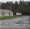
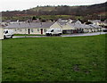
10
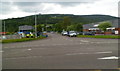
Entrance to Merthyr Tydfil Industrial Park
Viewed across Merthyr Road (A4054). The industrial park is located in the SE of Merthyr Tydfil, between Pentrebach and Troedyrhiw.
Image: © Jaggery
Taken: 13 Jun 2012
0.13 miles