IMAGES TAKEN NEAR TO
Pontsticill, MERTHYR TYDFIL, CF48 2UF
Introduction
This page details the photographs taken nearby to CF48 2UF by members of the Geograph project.
The Geograph project started in 2005 with the aim of publishing, organising and preserving representative images for every square kilometre of Great Britain, Ireland and the Isle of Man.

There are currently over 7.5m images from over14,400 individuals and you can help contribute to the project by visiting https://www.geograph.org.uk
Image Map
Images are licensed for reuse under creativecommons.org/licenses/by-sa/2.0
Notes
- Clicking on the map will re-center to the selected point.
- The higher the marker number, the further away the image location is from the centre of the postcode.
Image Listing (23 Images Found)
Images are licensed for reuse under creativecommons.org/licenses/by-sa/2.0
Image
Details
Distance
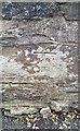
1
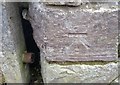
Ordnance Survey Cut Mark
This OS cut mark can be found on the wall east side of the road. It marks a point 340.910m above mean sea level.
Image: © Adrian Dust
Taken: 30 Oct 2019
0.02 miles
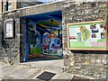
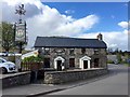
2
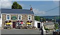
The Butchers Arms, Pontsticill
A restaurant and bunkhouse.
Image: © Robin Drayton
Taken: 9 Aug 2012
0.03 miles
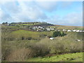
3
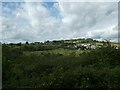
View to Pontsticill across Taff valley from Brecon Mountain Railway
Image: © David Smith
Taken: 21 Sep 2022
0.04 miles
4
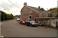
Red Cow Inn, Pontsticill
Located about a kilometre SW of Pontsticill station on the narrow-gauge Brecon Mountain Railway, and about 600 metres from the reservoir.
Image: © Jaggery
Taken: 25 Sep 2011
0.05 miles
5
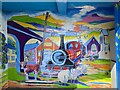
Bus shelter, Pontsticill
Colourfully painted bus shelter featuring several local tourist attractions. In addition to the Brecon Beacons in the background you can see the Pont Sarn viaduct, the Brecon Mountain Railway, Faenor Church and the local pub, The Red Cow.
Image: © Alan Hughes
Taken: 18 Sep 2022
0.05 miles
7
Ordnance Survey Cut Mark
This OS cut mark can be found on the NE face of the Memorial Hall. It marks a point 349.130m above mean sea level.
Image: © Adrian Dust
Taken: 30 Oct 2019
0.05 miles
8
Pontsticill from the Brecon Mountain Railway
Image: © Ruth Sharville
Taken: 28 Dec 2011
0.06 miles
9
Bilingual sign
I am reliably informed by people who know much more Welsh than I do that the Welsh version should read ‘Y Fuwch Goch’, with soft mutations.
Image: © Alan Hughes
Taken: 26 Aug 2020
0.09 miles
10
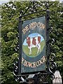
The Red Cow
The Red Cow at Pontstycill.
Image: © Alan Hughes
Taken: 26 Apr 2017
0.10 miles