1
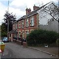
Lower Vaynor Road houses in Cefn-coed-y-cymmer
Viewed from the High Street end.
Image: © Jaggery
Taken: 16 Jun 2014
0.01 miles
2
St John the Baptist Church
Situated in the village of Cefn-coed-y-cymmer
Image: © Nick Earl
Taken: 19 Oct 2009
0.02 miles
3
Vaughan Terrace, Cefn-coed-y-cymmer
A separately named and numbered row of 3 houses alongside Brewery Lane.
Image: © Jaggery
Taken: 16 Jun 2014
0.04 miles
4
St. John's church, Cefn-coed-y-cymmer
A Victorian building on a rise of land to the north-west of Merthyr Tydfil.
Image: © Jonathan Billinger
Taken: 4 Oct 2008
0.05 miles
5
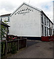
Monumental display of the Monumental Terrace name, Cefn-coed-y-cymmer
Late Victorian (1896) terrace on the north side of High Street.
Image: © Jaggery
Taken: 16 Jun 2014
0.05 miles
6
The Swiss Church, Cefn-coed-y-cymmer
St John the Baptist Church http://www.geograph.org.uk/photo/4050531 is also known as the Swiss Church because of this slated spire.
Image: © Jaggery
Taken: 16 Jun 2014
0.05 miles
7
Community Centre, Cefn-coed-y-cymmer
Viewed across New Church Street. John Maddan informs me that the building was originally a drill hall dating from c1884. In 1914 it was the base for G Company Brecknockshire Battalion South Wales Borderers. The building was returned to the village as a community centre in 1969.
The slated spire http://www.geograph.org.uk/photo/4050560 of St John the Baptist Church is in the background.
Image: © Jaggery
Taken: 16 Jun 2014
0.05 miles
8
Ordnance Survey Cut Mark
This OS cut mark can be found on the west angle of St John's Church. It marks a point 229.1822m above mean sea level.
Image: © Adrian Dust
Taken: 27 Apr 2014
0.05 miles
9
West side of St John the Baptist Church, Cefn-coed-y-cymmer
The entrance is from New Church Street. St John the Baptist Church, in the Church in Wales Diocese of Swansea & Brecon, dates from 1870. It is sometimes called the Swiss Church because of its slated spire.
Image: © Jaggery
Taken: 16 Jun 2014
0.05 miles
10
Church Hall in Cefn-coed-y-cymmer
In New Church Street, opposite the entrance http://www.geograph.org.uk/photo/4050531 to St John the Baptist Church.
Image: © Jaggery
Taken: 16 Jun 2014
0.05 miles


