IMAGES TAKEN NEAR TO
The Willows, MERTHYR TYDFIL, CF48 1YH
Introduction
This page details the photographs taken nearby to The Willows, CF48 1YH by members of the Geograph project.
The Geograph project started in 2005 with the aim of publishing, organising and preserving representative images for every square kilometre of Great Britain, Ireland and the Isle of Man.

There are currently over 7.5m images from over14,400 individuals and you can help contribute to the project by visiting https://www.geograph.org.uk
Image Map
Images are licensed for reuse under creativecommons.org/licenses/by-sa/2.0
Notes
- Clicking on the map will re-center to the selected point.
- The higher the marker number, the further away the image location is from the centre of the postcode.
Image Listing (40 Images Found)
Images are licensed for reuse under creativecommons.org/licenses/by-sa/2.0
Image
Details
Distance
1
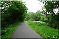
Path near Abercanaid Industrial Estate
The path is part of National Cycle Network route 8.
Image: © DS Pugh
Taken: 24 Jun 2024
0.05 miles
2
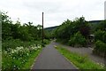
Cycle path south of Abercanaid Industrial Estate
The path is part of National Cycle Network route 8.
Image: © DS Pugh
Taken: 24 Jun 2024
0.13 miles
3

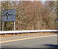
Cycle path sign south of Abercanaid Industrial Estate
The path ahead and behind is part of National Cycle Network route 8. Route 477 heads to the right.
Image: © DS Pugh
Taken: 24 Jun 2024
0.15 miles
4
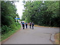
Llwybr Taf / Taff Trail
Cerddwyr yn dilyn Llwybr Taf ger Ty Glyndyrys.
Walkers following the Taff Trail near Glyndyrys House.
Image: © Alan Richards
Taken: 21 Jul 2018
0.16 miles
5
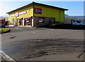
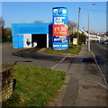
Speedy in Merthyr Tydfil
Speedy Equipment & Tool Hire on the west side of the A4054 Pentrebach Road.
Image: © Jaggery
Taken: 27 Feb 2019
0.16 miles
6
Arc Attended Car Wash in Merthyr Tydfil
Alongside the A4054 in the south of Merthyr Tydfil.
Image: © Jaggery
Taken: 27 Feb 2019
0.16 miles
7
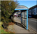
Bench and blue bus shelter, Plymouth Street, Merthyr Tydfil
The stop on the west side of the A4054 Plymouth Street is for
buses to central Merthyr Tydfil and Merthyr Tydfil bus station.
Image: © Jaggery
Taken: 27 Feb 2019
0.16 miles
8
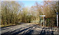
Side road in Abercanaid Industrial Estate
On the west side of the main road through the industrial estate.
Image: © Jaggery
Taken: 27 Feb 2019
0.16 miles
9
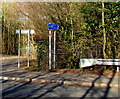
Taff Trail direction sign in Abercanaid Industrial Estate
The blue sign on the far right here https://www.geograph.org.uk/photo/6076349 shows that Taff Trail is Taith Taf in Welsh. Following the course of the River Taff, the Taff Trail is a walking and cycling route in Wales, extending for about 88km (55 miles) between Brecon and Cardiff Bay.
Image: © Jaggery
Taken: 27 Feb 2019
0.16 miles
10
Directions sign in Abercanaid Industrial Estate
On the approach to this https://www.geograph.org.uk/photo/6076247 roundabout.
Image: © Jaggery
Taken: 27 Feb 2019
0.16 miles