IMAGES TAKEN NEAR TO
Park View Terrace, MERTHYR TYDFIL, CF48 1SU
Introduction
This page details the photographs taken nearby to Park View Terrace, CF48 1SU by members of the Geograph project.
The Geograph project started in 2005 with the aim of publishing, organising and preserving representative images for every square kilometre of Great Britain, Ireland and the Isle of Man.

There are currently over 7.5m images from over14,400 individuals and you can help contribute to the project by visiting https://www.geograph.org.uk
Image Map
Images are licensed for reuse under creativecommons.org/licenses/by-sa/2.0
Notes
- Clicking on the map will re-center to the selected point.
- The higher the marker number, the further away the image location is from the centre of the postcode.
Image Listing (20 Images Found)
Images are licensed for reuse under creativecommons.org/licenses/by-sa/2.0
Image
Details
Distance
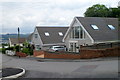
1
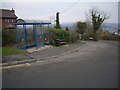
Bus terminus at Heolgerrig
Image: © Nick Mutton 01329 000000
Taken: 15 Dec 2007
0.02 miles
2
Gernant Lane, Heolgerrig, Merthyr Tydfil
Gernant Lane heads SW away from Heolgerrig towards an area of former coal tips that are being reclaimed by nature.
Image: © Jaggery
Taken: 13 Jun 2012
0.05 miles
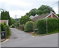
3
Turn right here for Winchfawr, Heolgerrig, Merthyr Tydfil
A sign outside number 89 Heolgerrig points right for the road to Winchfawr.
Image: © Jaggery
Taken: 13 Jun 2012
0.05 miles
4
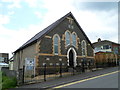
Calfaria Chapel, Heolgerrig, Merthyr Tydfil
There are a dozen foundation stones embedded in the facade of the Baptist chapel, six on each side of the doorway. The date shown is Mehefin 23 1902, Welsh for June 23, 1902.
Image: © Jaggery
Taken: 13 Jun 2012
0.05 miles
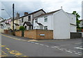
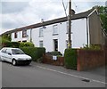
5
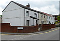
Houses on the corner of Andrews Close, Heolgerrig, Merthyr Tydfil
The Andrews Close turning is on the left.
Image: © Jaggery
Taken: 13 Jun 2012
0.05 miles
6
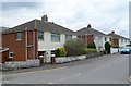
Andrews Close houses, Heolgerrig, Merthyr Tydfil
Semi-detached houses on the east side of Andrews Close viewed from the corner of Heolgerrig.
Image: © Jaggery
Taken: 13 Jun 2012
0.06 miles
7
Horeb Cottages and Tai Ysgol Fach, Heolgerrig, Merthyr Tydfil
Horeb Cottages are on the left, Tai Ysgol Fach houses on the right. Tai Ysgol Fach is Welsh for Little School Houses.
Image: © Jaggery
Taken: 13 Jun 2012
0.08 miles
8
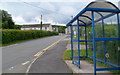
Heolgerrig bus shelter near the end of the route from Merthyr Tydfil bus station
The shelter is one stop away from the terminus ahead. The route from the centre of Merthyr Tydfil is mostly uphill. This shelter is at an elevation of about 290 metres (about 950 feet) above mean sea level.
Image: © Jaggery
Taken: 13 Jun 2012
0.09 miles
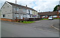
9
Heolgarrig houses NE of Beechwood Drive, Heolgerrig, Merthyr Tydfil
Heolgerrig is the name both of a district of Merthyr Tydfil and the main road through it.
Image: © Jaggery
Taken: 13 Jun 2012
0.09 miles
10
Belle Vue, Heolgerrig, Merthyr Tydfil
Though overpainted, the name Belle Vue is still legible between upstairs windows
of the house next door to the out-of-shot Red Lion pub. http://www.geograph.org.uk/photo/3003224
Image: © Jaggery
Taken: 13 Jun 2012
0.11 miles