IMAGES TAKEN NEAR TO
Old School Close, MERTHYR TYDFIL, CF48 1DA
Introduction
This page details the photographs taken nearby to Old School Close, CF48 1DA by members of the Geograph project.
The Geograph project started in 2005 with the aim of publishing, organising and preserving representative images for every square kilometre of Great Britain, Ireland and the Isle of Man.

There are currently over 7.5m images from over14,400 individuals and you can help contribute to the project by visiting https://www.geograph.org.uk
Image Map
Images are licensed for reuse under creativecommons.org/licenses/by-sa/2.0
Notes
- Clicking on the map will re-center to the selected point.
- The higher the marker number, the further away the image location is from the centre of the postcode.
Image Listing (86 Images Found)
Images are licensed for reuse under creativecommons.org/licenses/by-sa/2.0
Image
Details
Distance
1
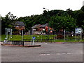
Junction in Georgetown, Merthyr Tydfil
At the junction of the A4102 and the A4054 Cyfarthfa Road, a sign points right for Cardiff, Brecon and Hirwaun.
Image: © Jaggery
Taken: 16 Jun 2014
0.06 miles
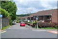
2
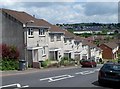
Houses on a slope, Heol S O Davies, Merthyr Tydfil
The houses are on the NE side of Heol S O Davies, named after a former local MP. http://www.geograph.org.uk/photo/3000580
Image: © Jaggery
Taken: 13 Jun 2012
0.09 miles
3
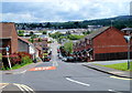
Heol S O Davies, Merthyr Tydfil
A view NE from the corner of Aberdare Road.
Heol is Welsh for path, lane, street or road.
S O (Stephen Owen) Davies was MP (Member of Parliament) for Merthyr from 1934-1950 and Merthyr Tydfil from 1950 until his death in 1972. The two constituencies covered much of the same area.
Image: © Jaggery
Taken: 13 Jun 2012
0.09 miles
4
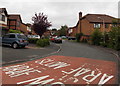
Chapel Banks, Merthyr Tydfil
Cul-de-sac in the Georgetown area of Merthyr, between the A4102 and the River Taff.
Image: © Jaggery
Taken: 16 Jun 2014
0.10 miles
5
Llwyn Dic Penderyn, Merthyr Tydfil
Viewed from the corner of Heol S O Davies. http://www.geograph.org.uk/photo/3000580 Llwyn is Welsh for a bush, grove or wood.
Richard Lewis, better known as Dic Penderyn, was a Welsh labourer and coal miner. During a riot in the 1831 Merthyr Rising, he was arrested and charged with bayonetting a soldier. Many local people doubted his guilt, and many signed a petition for his release. He was found guilty and hanged on August 23rd 1831. He was regarded as a martyr in Merthyr, and across the UK.
Image: © Jaggery
Taken: 13 Jun 2012
0.11 miles
6
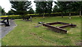
Early 19th century iron frame near Chapel Row, Merthyr Tydfil
Dated 1815, this is one of several iron artefacts on display opposite Chapel Row, http://www.geograph.org.uk/photo/4620689
which was built in the 1820s for the workers of Cyfarthfa Ironworks.
Image: © Jaggery
Taken: 16 Jun 2014
0.11 miles
7
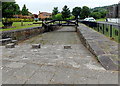
Iron bridge opposite Chapel Row, Merthyr Tydfil
Originally a canal bridge in Rhydycar, now located opposite Chapel Row. http://www.geograph.org.uk/photo/4620689
Image: © Jaggery
Taken: 16 Jun 2014
0.11 miles
8
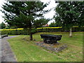
Iron truck near Chapel Row, Merthyr Tydfil
One of several iron artefacts on display opposite Chapel Row, http://www.geograph.org.uk/photo/4620689
which was built in the 1820s for the workers of Cyfarthfa Ironworks.
Image: © Jaggery
Taken: 16 Jun 2014
0.11 miles
9
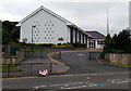
Church of Jesus Christ of Latter Day Saints, Merthyr Tydfil
Cyfarthfa Road entrance to the church on the corner of Swansea Road.
Image: © Jaggery
Taken: 16 Jun 2014
0.11 miles
10
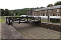
Iron canal bridge opposite Chapel Row, Merthyr Tydfil
Originally a canal bridge in Rhydycar, now located opposite Chapel Row. http://www.geograph.org.uk/photo/4620689
Image: © Jaggery
Taken: 16 Jun 2014
0.11 miles