IMAGES TAKEN NEAR TO
Plantation Close, MERTHYR TYDFIL, CF47 9LN
Introduction
This page details the photographs taken nearby to Plantation Close, CF47 9LN by members of the Geograph project.
The Geograph project started in 2005 with the aim of publishing, organising and preserving representative images for every square kilometre of Great Britain, Ireland and the Isle of Man.

There are currently over 7.5m images from over14,400 individuals and you can help contribute to the project by visiting https://www.geograph.org.uk
Image Map
Images are licensed for reuse under creativecommons.org/licenses/by-sa/2.0
Notes
- Clicking on the map will re-center to the selected point.
- The higher the marker number, the further away the image location is from the centre of the postcode.
Image Listing (17 Images Found)
Images are licensed for reuse under creativecommons.org/licenses/by-sa/2.0
Image
Details
Distance

2
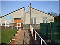
Trevithick Industrial Estate, Merthyr Tydfil
On the occasion of the 200th anniversary of Trevithick's Pen-y-Darren locomotive.
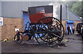
The photograph includes the replica of trevithick's 1803 London steam carriage. Not sure I would fancy sitting so high up and with one of Trevithick's high pressure boilers below (James Watt was particularly against the evils of strong steam).
Image: © Chris Allen
Taken: 4 Jul 2004
0.10 miles
3
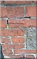
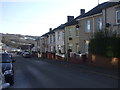
Ordnance Survey Cut Mark
This OS cut mark can be the NE side of Lewis Terrace. It marks a point 246.961m above mean sea level.
Image: © Adrian Dust
Taken: 5 Nov 2017
0.10 miles
4
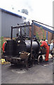
Replica of trevithick's "Puffing Devil"
Built by the Trevithick Society and regularly demonstrated in its native Cornwall.
Image: © Chris Allen
Taken: 4 Jul 2004
0.11 miles

8
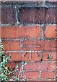
Ordnance Survey Cut Mark
This OS cut mark can be found on wall between Nos19 & 20 Royal Crescent. It marks a point 255.514m above mean sea level.
Image: © Adrian Dust
Taken: 5 Nov 2017
0.17 miles