IMAGES TAKEN NEAR TO
Penydre, MERTHYR TYDFIL, CF47 9DY
Introduction
This page details the photographs taken nearby to Penydre, CF47 9DY by members of the Geograph project.
The Geograph project started in 2005 with the aim of publishing, organising and preserving representative images for every square kilometre of Great Britain, Ireland and the Isle of Man.

There are currently over 7.5m images from over14,400 individuals and you can help contribute to the project by visiting https://www.geograph.org.uk
Image Map
Images are licensed for reuse under creativecommons.org/licenses/by-sa/2.0
Notes
- Clicking on the map will re-center to the selected point.
- The higher the marker number, the further away the image location is from the centre of the postcode.
Image Listing (6 Images Found)
Images are licensed for reuse under creativecommons.org/licenses/by-sa/2.0
Image
Details
Distance
1
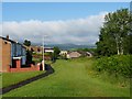
Gurnos Estate, Merthyr Tydfil
A view looking west on the northern edge of this large estate.
Image: © Robin Drayton
Taken: 18 Jun 2012
0.06 miles
2
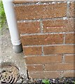
Ordnance Survey Cut Mark
This OS cut mark can be found on No70 Forsythia Close. It marks a point 286.390m above mean sea level.
Image: © Adrian Dust
Taken: 14 Jun 2018
0.09 miles
3
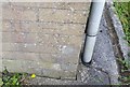
Ordnance Survey Cut Mark
This OS cut mark can be found on No75 Lupin Close. It marks a point 277.697m above mean sea level.
Image: © Adrian Dust
Taken: 14 Jun 2018
0.12 miles
4
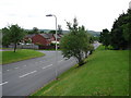
Top End of Gurnos
View of housing, the embankment to the A465 and estate roads at the north of Gurnos, Merthyr Tydfil.
Image: © Ian Paterson
Taken: 3 Jun 2008
0.13 miles
5
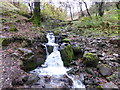
A stream joins the Taf Fechan
This lively little tributary bundles in from this small valley.
Image: © Jeremy Bolwell
Taken: 26 Oct 2013
0.22 miles
6
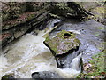
Part of the Taf Fechan
Just one of many features along this stream.
Image: © Jeremy Bolwell
Taken: 26 Oct 2013
0.23 miles