IMAGES TAKEN NEAR TO
Pontmorlais, MERTHYR TYDFIL, CF47 8UH
Introduction
This page details the photographs taken nearby to Pontmorlais, CF47 8UH by members of the Geograph project.
The Geograph project started in 2005 with the aim of publishing, organising and preserving representative images for every square kilometre of Great Britain, Ireland and the Isle of Man.

There are currently over 7.5m images from over14,400 individuals and you can help contribute to the project by visiting https://www.geograph.org.uk
Image Map
Images are licensed for reuse under creativecommons.org/licenses/by-sa/2.0
Notes
- Clicking on the map will re-center to the selected point.
- The higher the marker number, the further away the image location is from the centre of the postcode.
Image Listing (168 Images Found)
Images are licensed for reuse under creativecommons.org/licenses/by-sa/2.0
Image
Details
Distance
2
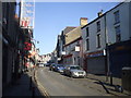
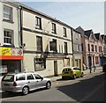
Pontmorlais, Merthyr Tydfil
The view south along Pontmorlais, a narrow street in central Merthyr Tydfil.
The pink building on the left is the Imperial Hotel. At the left edge of the photo is part of the derelict former Morlais Castle Inn. http://www.geograph.org.uk/photo/1825962
Image: © Jaggery
Taken: 21 Apr 2010
0.02 miles
3
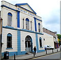
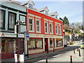
Grade II listed former Wesley Chapel, Merthyr Tydfil
Located in Pontmorlais, a separately-named section of High Street. This is an 1862 rebuild of the original chapel dating from 1797. Since closure as a chapel, the building has had various secular uses, such as a furniture shop.
Grade II listed in January 1988.
Image: © Jaggery
Taken: 13 Jun 2012
0.02 miles
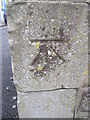
4
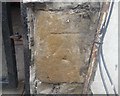
Ordnance Survey Cut Mark
This OS cut mark can be found on the building which was once the Mile End PH. It marks a point 180.4197m above mean sea level.
Image: © Adrian Dust
Taken: 26 Jul 2020
0.03 miles
5
Derelict Morlais Castle Inn, Merthyr Tydfil
From its external appearance, the former Morlais Castle Inn at 75 Pontmorlais in central Merthyr Tydfil appears to have been disused for some time.
Image: © Jaggery
Taken: 21 Apr 2010
0.04 miles
6
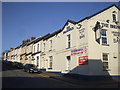
Bob Wilding Motorcycles, Merthyr Tydfil
Motor cycles and ATVs (all-terrain vehicles) shop at 20-22 Pontmorlais, central Merthyr Tydfil.
Image: © Jaggery
Taken: 21 Apr 2010
0.04 miles
7

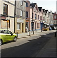
High Street, Merthyr Tydfil
As depressing a street as you could find anywhere in the British Isles.
Image: © Roger Cornfoot
Taken: 29 Jun 2014
0.04 miles
9
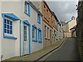
Roberts Lane, Merthyr Tydfil
A side street off the High Street to the left of Sovereign Grace Church http://www.geograph.org.uk/photo/3001940 .
Image: © Robin Drayton
Taken: 4 Mar 2014
0.05 miles
10
Ordnance Survey Cut Mark
This OS cut mark can be found on a wall post in front of Hope Chapel. It marks a point 179.207m above mean sea level.
Image: © Adrian Dust
Taken: 13 Jun 2015
0.05 miles