IMAGES TAKEN NEAR TO
Saxon Street, MERTHYR TYDFIL, CF47 8SP
Introduction
This page details the photographs taken nearby to Saxon Street, CF47 8SP by members of the Geograph project.
The Geograph project started in 2005 with the aim of publishing, organising and preserving representative images for every square kilometre of Great Britain, Ireland and the Isle of Man.

There are currently over 7.5m images from over14,400 individuals and you can help contribute to the project by visiting https://www.geograph.org.uk
Image Map
Images are licensed for reuse under creativecommons.org/licenses/by-sa/2.0
Notes
- Clicking on the map will re-center to the selected point.
- The higher the marker number, the further away the image location is from the centre of the postcode.
Image Listing (51 Images Found)
Images are licensed for reuse under creativecommons.org/licenses/by-sa/2.0
Image
Details
Distance
1
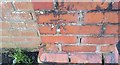
Ordnance Survey Cut Mark
This OS cut mark can be found on the wall post SE side if Dane Street. It marks a point 208.660m above mean sea level.
Image: © Adrian Dust
Taken: 5 Nov 2017
0.03 miles
2
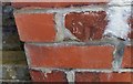
Ordnance Survey Cut Mark
This tiny part of an OS cut mark can be found on the wall post of the school on Norman Terrace. It marked a point 201.391m above mean sea level.
Image: © Adrian Dust
Taken: 5 Nov 2017
0.06 miles

4
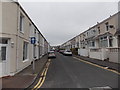
Cromwell Street, Merthyr Tydfil
Viewed from the NW end of Tudor Terrace looking along Cromwell Street towards Stuart Street.
Image: © Jaggery
Taken: 16 Jun 2014
0.09 miles
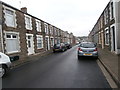
6

Long row of houses, Cromwell Street, Merthyr Tydfil
Viewed from the corner of Vulcan Road.
Image: © Jaggery
Taken: 16 Jun 2014
0.10 miles
7

Ordnance Survey Cut Mark
This OS cut mark can be found on the wall between No1 & 2 The Grove. It marks a point 208.703m above mean sea level.
Image: © Adrian Dust
Taken: 26 Jul 2020
0.11 miles
9

Ordnance Survey Cut Mark
This OS cut mark can be found on the SW angle of the Baptist Chapel, The Walk. It marks a point 198.382m above mean sea level.
Image: © Adrian Dust
Taken: 26 Jul 2020
0.12 miles