IMAGES TAKEN NEAR TO
Brecon Road, MERTHYR TYDFIL, CF47 8RB
Introduction
This page details the photographs taken nearby to Brecon Road, CF47 8RB by members of the Geograph project.
The Geograph project started in 2005 with the aim of publishing, organising and preserving representative images for every square kilometre of Great Britain, Ireland and the Isle of Man.

There are currently over 7.5m images from over14,400 individuals and you can help contribute to the project by visiting https://www.geograph.org.uk
Image Map
Images are licensed for reuse under creativecommons.org/licenses/by-sa/2.0
Notes
- Clicking on the map will re-center to the selected point.
- The higher the marker number, the further away the image location is from the centre of the postcode.
Image Listing (99 Images Found)
Images are licensed for reuse under creativecommons.org/licenses/by-sa/2.0
Image
Details
Distance
1
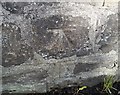
Ordnance Survey Cut Mark
This OS cut mark can be found on the wall of Cyfarthfa Park, Brecon Road. It marks a point 198.259m above mean sea level.
Image: © Adrian Dust
Taken: 5 Nov 2017
0.06 miles
2
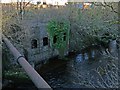
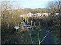
Former hydroelectric building, Merthyr Tydfil
This water turbine house is situated beside the River Taff next to Pont-y-Cafnau http://www.geograph.org.uk/photo/3315176 .
From 1928 to 1939 electricity that was generated here powered tramcars in Merthyr Tydfil.
It closed in 1953.
Image: © Robin Drayton
Taken: 9 Jan 2013
0.06 miles
3
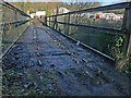
Pont-y-Cafnau trackbed, Merthyr Tydfil
Image: © Robin Drayton
Taken: 9 Jan 2013
0.07 miles
4
Side view of Pont-y-Cafnau, Merthyr Tydfil
Image: © Robin Drayton
Taken: 9 Jan 2013
0.07 miles
5
Pont-y-Cafnau from the south-west, Merthyr Tydfil
Image: © Robin Drayton
Taken: 9 Jan 2013
0.07 miles
6
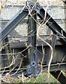
Pont-y-Cafnau
Dovetail joints in the cast iron structure of the pont-y-cafnau, an early iron bridge and the first cast iron railway bridge.
Image: © Andy Dingley
Taken: 23 Nov 2012
0.07 miles
7
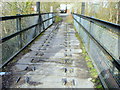
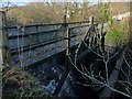
Pont y Cafnau iron rail bridge and aqueduct (1793)
The Pont y Cafnau iron bridge has been acknowledged as the world's oldest surviving iron railway bridge [ - see Context for World Heritage Bridges
A joint publication with TICCIH, 1996, By Eric DeLony http://www.icomos.org/studies/bridges.htm ; and Hague, D and Hughes, S - Pont Y Cafnau, the first iron railway bridge and aqueduct? - Ass. Industrial Archaeology Bulletin, 1982, 9, No4, 3-4 ].
The Pont y Cafnau bridge is located just below the confluence of the Afon Taf Fawr and the Afon Taf Fechan rivers; it is used as a public footpath and may be used to cross the river and connect the Taff Trail waymarked path with the nearby Cyfarthfa Castle.
This is a unique cast-iron bridge, a two-deck combined aqueduct and tramroad bridge built by the chief engineer of the Cyfarthfa ironworks, to carry both the works' tram line from the nearby limestone quarries at Gurnos and its water supply over the river. Its diminutive scale notwithstanding, this was an important early prototype for iron bridge construction that influenced Telford's monumental feats of engineering such as the celebrated Pontcysyllte and Chirk aqueducts. [ See The International Canal Monuments List, and. http://www.icomos.org/studies/canals2a.htm ]
Image: © John Wilson
Taken: 9 Mar 2007
0.07 miles
8
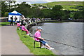
School Fishing Competition, Cyfarthfa Castle Lake - Merthyr Tydfil
The Merthyr Tydfil Angling Association hosts an inter-school fishing competition. Here pupils from one school compete to land the biggest fish in order for the winner to go on into the next round.
Image: © Mick Lobb
Taken: 16 Jun 2009
0.07 miles
9

Cymer/confluence
An early spring view of the spot where the waters of the two Taffs - Taf Fawr and Taf Fechan - meet.
Image: © Alan Bowring
Taken: 20 Mar 2014
0.08 miles
10
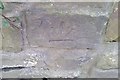
Ordnance Survey Cut Mark
This inverted OS cut mark can be found on the wall SW side of Brecon Road. It marks a point 195.770m above mean sea level.
Image: © Adrian Dust
Taken: 5 Nov 2017
0.08 miles