IMAGES TAKEN NEAR TO
Bethesda Street, MERTHYR TYDFIL, CF47 8PY
Introduction
This page details the photographs taken nearby to Bethesda Street, CF47 8PY by members of the Geograph project.
The Geograph project started in 2005 with the aim of publishing, organising and preserving representative images for every square kilometre of Great Britain, Ireland and the Isle of Man.

There are currently over 7.5m images from over14,400 individuals and you can help contribute to the project by visiting https://www.geograph.org.uk
Image Map
Images are licensed for reuse under creativecommons.org/licenses/by-sa/2.0
Notes
- Clicking on the map will re-center to the selected point.
- The higher the marker number, the further away the image location is from the centre of the postcode.
Image Listing (173 Images Found)
Images are licensed for reuse under creativecommons.org/licenses/by-sa/2.0
Image
Details
Distance
1
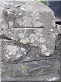
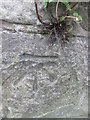
Ordnance Survey Cut Mark
This OS cut mark can be found on the wall of St Mary's Church. It marks a point 187.999m above mean sea level.
Image: © Adrian Dust
Taken: 13 Jun 2015
0.03 miles
2
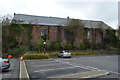
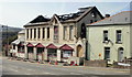
Former Drill Hall - Pont Morlais Road West
Garage premises in dilapidated Great War drill hall.
Image: © John M
Taken: 3 Apr 2015
0.05 miles
3
Ordnance Survey Cut Mark
This OS cut mark can be found on the steps wall leading to Abermorlais Terrace. It marks a point 189.857m above mean sea level.
Image: © Adrian Dust
Taken: 13 Jun 2015
0.05 miles
4
Rear of former drill hall - Pont Morlais Road West
Great War drill hall now used as garage premises.
Image: © John M
Taken: 3 Apr 2015
0.06 miles
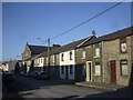
5
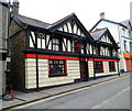
The Vulcan Inn, Merthyr Tydfil
High Street pub. A silver-on-black banner across two upstairs windows proclaims
THE VULCAN NIGHTCLUB MERTHYR'S PREMIER VENUE.
Image: © Jaggery
Taken: 13 Jun 2012
0.07 miles
6
Orient Express, Merthyr Tydfil
Chinese restaurant at 1-2 Pontmorlais, a separately-named part of High Street.
The premise's name is a partial reference to the building's former use as Ye Olde Express Inn.
Image: © Jaggery
Taken: 13 Jun 2012
0.07 miles
7
The Anchor, Merthyr Tydfil
Town centre pub at 96 Pontmorlais. There is a Referred Commercial for sale sign on the building.
Image: © Jaggery
Taken: 13 Jun 2012
0.07 miles
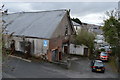
8
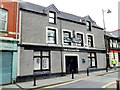
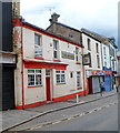
Fire-damaged building, Bethesda Street, Merthyr Tydfil
On December 28th 2009, fire severely damaged an unoccupied building on Bethesda Street, formerly known as RM’s Rock Club. The two-storey building had been sold earlier in the month to an undisclosed purchaser.
The club holds happy memories for music fans throughout the South Wales valleys, and inspired many musicians over the years. In its heyday, RM’s Rock Club – based in the upstairs nightclub – was the place to be for up and coming bands, who came from far and wide to play to the crowds. But the rock club closed at the end of 2005, because of dwindling public support.
Over the years the downstairs section has had various uses, including Bethesda Brasserie, a Chinese restaurant, and a Fun Pub. The club itself had run under a number of names including Shooters, Barnies, and NV.
Image: © Jaggery
Taken: 21 Apr 2010
0.07 miles