IMAGES TAKEN NEAR TO
Pandy Close, MERTHYR TYDFIL, CF47 8PB
Introduction
This page details the photographs taken nearby to Pandy Close, CF47 8PB by members of the Geograph project.
The Geograph project started in 2005 with the aim of publishing, organising and preserving representative images for every square kilometre of Great Britain, Ireland and the Isle of Man.

There are currently over 7.5m images from over14,400 individuals and you can help contribute to the project by visiting https://www.geograph.org.uk
Image Map
Images are licensed for reuse under creativecommons.org/licenses/by-sa/2.0
Notes
- Clicking on the map will re-center to the selected point.
- The higher the marker number, the further away the image location is from the centre of the postcode.
Image Listing (112 Images Found)
Images are licensed for reuse under creativecommons.org/licenses/by-sa/2.0
Image
Details
Distance
1
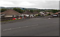
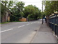
Pandy Close, Merthyr Tydfil
Cul-de-sac of mostly bungalows viewed across Cyfarthfa Road.
Image: © Jaggery
Taken: 16 Jun 2014
0.03 miles
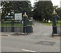
2
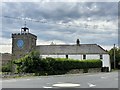
Clock tower at Pandy Farm
A grade II listed building constructed in 1826 in the same style as nearby Cyfarthfa Castle.
Image: © Alan Hughes
Taken: 31 Jul 2020
0.04 miles
3
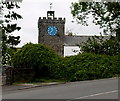
Clock tower in the SE corner of Pandy Farm, Merthyr Tydfil
Viewed across Cyfarthfa Road.
Image: © Jaggery
Taken: 16 Jun 2014
0.04 miles
4
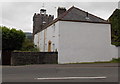
Pandy Farm, Merthyr Tydfil
Alongside Brecon Road, opposite an entrance http://www.geograph.org.uk/photo/4620803 to Cyfarthfa Park. http://www.geograph.org.uk/photo/4499215 to a view of the tower and clock.
Image: © Jaggery
Taken: 16 Jun 2014
0.04 miles
5
Brecon Road, Merthyr Tydfil
The A4054 Brecon Road passes the SW edge of Cyfarthfa Park on the right.
Image: © Jaggery
Taken: 16 Jun 2014
0.05 miles
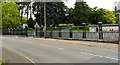
6
SE entrance to Cyfarthfa Park, Merthyr Tydfil
From Brecon Road. This entrance is for walkers, cyclists and private light vehicles.
There is a 12' 6" width restriction through the gates. A black arrow points left towards an alternative route.
Image: © Jaggery
Taken: 16 Jun 2014
0.06 miles
7
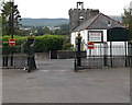
No exit from Cyfarthfa Park, Merthyr Tydfil
Entrance only - follow signs to the western exit.
Image: © Jaggery
Taken: 16 Jun 2014
0.06 miles
8
Ornate perimeter railings, Cyfarthfa Park, Merthyr Tydfil
Viewed across Brecon Road towards this http://www.geograph.org.uk/photo/4620803 entrance.
Image: © Jaggery
Taken: 16 Jun 2014
0.06 miles
9
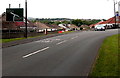
Cyfarthfa Road approaches the Brecon Road junction in Merthyr Tydfil
Left for Brecon or right for Merthyr town centre ahead. The car is emerging from Pandy Close. http://www.geograph.org.uk/photo/4499142
Image: © Jaggery
Taken: 16 Jun 2014
0.06 miles
10
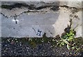
Ordnance Survey Cut Mark
This OS cut mark can be found on the wall of Cyfarthfa Park, right of entrance gates. It marks a point 192.202m above mean sea level.
Image: © Adrian Dust
Taken: 5 Nov 2017
0.06 miles