IMAGES TAKEN NEAR TO
Bethesda Street, MERTHYR TYDFIL, CF47 8LL
Introduction
This page details the photographs taken nearby to Bethesda Street, CF47 8LL by members of the Geograph project.
The Geograph project started in 2005 with the aim of publishing, organising and preserving representative images for every square kilometre of Great Britain, Ireland and the Isle of Man.

There are currently over 7.5m images from over14,400 individuals and you can help contribute to the project by visiting https://www.geograph.org.uk
Image Map
Images are licensed for reuse under creativecommons.org/licenses/by-sa/2.0
Notes
- Clicking on the map will re-center to the selected point.
- The higher the marker number, the further away the image location is from the centre of the postcode.
Image Listing (107 Images Found)
Images are licensed for reuse under creativecommons.org/licenses/by-sa/2.0
Image
Details
Distance
1

Red Spice, Merthyr Tydfil
Bangladeshi and Indian cuisine restaurant at 1 Bethesda Street in the Georgetown
area of Merthyr Tydfil. In June 2012, this building housed The Wellington Brasserie. http://www.geograph.org.uk/photo/3000674
Brown signs on the right point left and right along the Taff Trail, part of National Cycle Network route 8.
Image: © Jaggery
Taken: 16 Jun 2014
0.01 miles
2
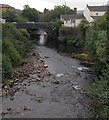
Jackson's Bridge, Merthyr Tydfil
Viewed along the River Taff from the A4102. Dating from the early 19th century, the stone bridge
which now carries Bethesda Street over the Taff formerly also carried the Dowlais Tramroad.
Image: © Jaggery
Taken: 16 Jun 2014
0.02 miles
3
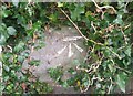
Ordnance Survey Cut Mark
This OS cut mark can be found on the SE parapet of Jacksons Bridge. It marks a point 173.132m above mean sea level.
Image: © Adrian Dust
Taken: 26 Jul 2020
0.02 miles
5
Eagle Inn electricity substation in Merthyr Tydfil
The ID label on an electricity substation is sometimes useful in identifying a neighbouring building where the usage has changed. Such is the case here. This Western Power Distribution electricity substation has the identifier EAGEL (a typo for EAGLE) INN MERTHYR S/S 552918 which helped
in the identification of this http://www.geograph.org.uk/photo/4044998 building,
Image: © Jaggery
Taken: 16 Jun 2014
0.02 miles
6

Former Eagle Inn, Merthyr Tydfil
On the corner of Quarry Road and Vincent Place. Converted to residential use, the building retains the bracket that used to support the Eagle name sign, on the wall between upstairs windows.
Image: © Jaggery
Taken: 16 Jun 2014
0.03 miles
7
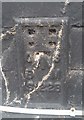
Ordnance Survey Flush Bracket (S1228)
This OS Flush Bracket can be found on the Eagle Inn, Quarry Row. It marks a point 173.862m above mean sea level.
Image: © Adrian Dust
Taken: 26 Jul 2020
0.03 miles
8
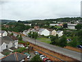
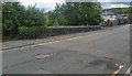
The A 4054
The photo was taken from the third floor of a nearby office building.
Image: © Ruth Sharville
Taken: 18 Jun 2009
0.03 miles
9

Quarry Row, Merthyr Tydfil
Looking NW along Quarry Row from near the corner of Vulcan Road.
Image: © Jaggery
Taken: 16 Jun 2014
0.04 miles
10
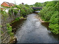
River Taff between two bridges, Merthyr Tydfil
Viewed from Bethesda Street on Jackson's Bridge looking upstream along the Taff towards the A4102 bridge.
Image: © Jaggery
Taken: 13 Jun 2012
0.04 miles