IMAGES TAKEN NEAR TO
Newfoundland Terrace, MERTHYR TYDFIL, CF47 8LA
Introduction
This page details the photographs taken nearby to Newfoundland Terrace, CF47 8LA by members of the Geograph project.
The Geograph project started in 2005 with the aim of publishing, organising and preserving representative images for every square kilometre of Great Britain, Ireland and the Isle of Man.

There are currently over 7.5m images from over14,400 individuals and you can help contribute to the project by visiting https://www.geograph.org.uk
Image Map
Images are licensed for reuse under creativecommons.org/licenses/by-sa/2.0
Notes
- Clicking on the map will re-center to the selected point.
- The higher the marker number, the further away the image location is from the centre of the postcode.
Image Listing (171 Images Found)
Images are licensed for reuse under creativecommons.org/licenses/by-sa/2.0
Image
Details
Distance
1
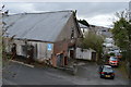
Former Drill Hall - Pont Morlais Road West
Garage premises in dilapidated Great War drill hall.
Image: © John M
Taken: 3 Apr 2015
0.02 miles
2
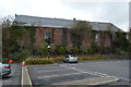
Rear of former drill hall - Pont Morlais Road West
Great War drill hall now used as garage premises.
Image: © John M
Taken: 3 Apr 2015
0.03 miles
3
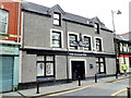
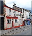
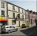
The Vulcan Inn, Merthyr Tydfil
High Street pub. A silver-on-black banner across two upstairs windows proclaims
THE VULCAN NIGHTCLUB MERTHYR'S PREMIER VENUE.
Image: © Jaggery
Taken: 13 Jun 2012
0.05 miles
4
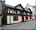
Orient Express, Merthyr Tydfil
Chinese restaurant at 1-2 Pontmorlais, a separately-named part of High Street.
The premise's name is a partial reference to the building's former use as Ye Olde Express Inn.
Image: © Jaggery
Taken: 13 Jun 2012
0.05 miles
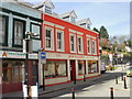
5
The Anchor, Merthyr Tydfil
Town centre pub at 96 Pontmorlais. There is a Referred Commercial for sale sign on the building.
Image: © Jaggery
Taken: 13 Jun 2012
0.05 miles
6
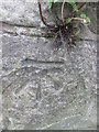
Ordnance Survey Cut Mark
This OS cut mark can be found on the steps wall leading to Abermorlais Terrace. It marks a point 189.857m above mean sea level.
Image: © Adrian Dust
Taken: 13 Jun 2015
0.05 miles
7
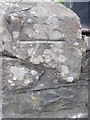
Ordnance Survey Cut Mark
This OS cut mark can be found on the wall of St Mary's Church. It marks a point 187.999m above mean sea level.
Image: © Adrian Dust
Taken: 13 Jun 2015
0.05 miles
8
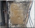
Ordnance Survey Cut Mark
This OS cut mark can be found on the building which was once the Mile End PH. It marks a point 180.4197m above mean sea level.
Image: © Adrian Dust
Taken: 26 Jul 2020
0.06 miles
9
Derelict Morlais Castle Inn, Merthyr Tydfil
From its external appearance, the former Morlais Castle Inn at 75 Pontmorlais in central Merthyr Tydfil appears to have been disused for some time.
Image: © Jaggery
Taken: 21 Apr 2010
0.07 miles
10
Bob Wilding Motorcycles, Merthyr Tydfil
Motor cycles and ATVs (all-terrain vehicles) shop at 20-22 Pontmorlais, central Merthyr Tydfil.
Image: © Jaggery
Taken: 21 Apr 2010
0.07 miles