IMAGES TAKEN NEAR TO
MERTHYR TYDFIL, CF47 8JD

Introduction

This page details the photographs taken nearby to CF47 8JD by members of the Geograph project.

The Geograph project started in 2005 with the aim of publishing, organising and preserving representative images for every square kilometre of Great Britain, Ireland and the Isle of Man.

There are currently over 7.5m images from over14,400 individuals and you can help contribute to the project by visiting https://www.geograph.org.uk

Image Map


Images are licensed for reuse under creativecommons.org/licenses/by-sa/2.0
Notes
  • Clicking on the map will re-center to the selected point.
  • The higher the marker number, the further away the image location is from the centre of the postcode.

Image Listing (201 Images Found)

Images are licensed for reuse under creativecommons.org/licenses/by-sa/2.0
  • ...
Image
Details
Distance
1
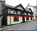
The Vulcan Inn, Merthyr Tydfil
High Street pub. A silver-on-black banner across two upstairs windows proclaims THE VULCAN NIGHTCLUB MERTHYR'S PREMIER VENUE.
Image: © Jaggery Taken: 13 Jun 2012
0.00 miles
2
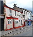
Orient Express, Merthyr Tydfil
Chinese restaurant at 1-2 Pontmorlais, a separately-named part of High Street. The premise's name is a partial reference to the building's former use as Ye Olde Express Inn.
Image: © Jaggery Taken: 13 Jun 2012
0.00 miles
3
The Anchor, Merthyr Tydfil
Town centre pub at 96 Pontmorlais. There is a Referred Commercial for sale sign on the building.
Image: © Jaggery Taken: 13 Jun 2012
0.00 miles
4
Merthyr Tydfil Exchange
The exchange (code SWMT/EX) in Merthyr Tydfil town centre provides broadband and telephone services for about 17,300 residential premises and 680 non-residential premises.
Image: © Jaggery Taken: 27 Feb 2019
0.02 miles
5
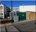
Castle Street electricity substation, Merthyr Tydfil
On the right here https://www.geograph.org.uk/photo/6168951 the green cabinet is a Western Power Distribution electricity substation. Its identifier is CASTLE ST GPO S/S 55-2942.
Image: © Jaggery Taken: 27 Feb 2019
0.03 miles
6
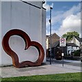
Calon gref, calon haearn/Strong heart, iron heart
This sculpture by David Appleyard was installed in Penderyn Square in Merthyr Tydfil in 2017. It honours Richard Lewis, known as Dic Penderyn, who was hanged in Cardiff on the 13th August 1831, for his part in the Chartist Rising in Merthyr. Penderyn was convicted of stabbing and wounding a soldier with a bayonet, on very shaky evidence, and came to be considered a martyr by the working people of the town and of Wales generally. The heart is made from steel derived from iron from the Cyfarthfa ironworks in the town; cuts to the wages of the already hard-pressed workers at Cyfarthfa were among the sparks that ignited the uprising. Before the heart are four sandstone slabs, letter-carved by John Neilsen with a poem commissioned from Gillian Clarke: The Rising Bearing their Welsh, their hunger, cold, they trudged the roads from Ceredigion, Carmarthenshire, the lonely upland farms, to Merthyr and a dream of gold. Ironstone miners, puddlers. Their hearts of iron made their masters rich, Merthyr our biggest town, twenty-thousand by eighteen thirty one, that blazing day a working class was born. They gathered beneath the peaks of Pen-y-Fan, Corn Ddu, Cribyn, and soldiers shot them down. Lament injustice, slaughter, the good man hanged as a warning: Dic Penderyn. Yn gweithio ym mwyngloddiau’r dwyrain, ifanc, dewr, Dic Penderyn, calon gref, calon haearn, dieuog i’r crocbren. The final stanza is an englyn, a traditional Welsh poetic form, and speaks of Penderyn's "strong heart, iron heart, innocent to the gallows." For the inscriptions, see Image] and Image See also David Appleyard's site https://www.davidappleyard.co.uk/merthyr-heart , also Wikipedia on Penderyn https://en.m.wikipedia.org/wiki/Dic_Penderyn and on the Merthyr Rising https://en.m.wikipedia.org/wiki/Merthyr_Rising .
Image: © A J Paxton Taken: 6 Aug 2024
0.03 miles
7
The Rising, part II
For more information, see Image
Image: © A J Paxton Taken: 6 Aug 2024
0.04 miles
8
The Rising, part I
For more information, see Image
Image: © A J Paxton Taken: 6 Aug 2024
0.04 miles
9
Ordnance Survey Cut Mark
This OS cut mark can be found on a wall post in front of Hope Chapel. It marks a point 179.207m above mean sea level.
Image: © Adrian Dust Taken: 13 Jun 2015
0.04 miles
10
Ordnance Survey Cut Mark
This OS cut mark can be found on the building which was once the Mile End PH. It marks a point 180.4197m above mean sea level.
Image: © Adrian Dust Taken: 26 Jul 2020
0.04 miles
  • ...