IMAGES TAKEN NEAR TO
Lower High Street, MERTHYR TYDFIL, CF47 8EB
Introduction
This page details the photographs taken nearby to Lower High Street, CF47 8EB by members of the Geograph project.
The Geograph project started in 2005 with the aim of publishing, organising and preserving representative images for every square kilometre of Great Britain, Ireland and the Isle of Man.

There are currently over 7.5m images from over14,400 individuals and you can help contribute to the project by visiting https://www.geograph.org.uk
Image Map
Images are licensed for reuse under creativecommons.org/licenses/by-sa/2.0
Notes
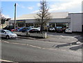
- Clicking on the map will re-center to the selected point.
- The higher the marker number, the further away the image location is from the centre of the postcode.
Image Listing (159 Images Found)
Images are licensed for reuse under creativecommons.org/licenses/by-sa/2.0
Image
Details
Distance
1
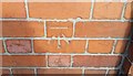
Ordnance Survey Cut Mark
This OS cut mark can be found on the Ex-Servicemen's Club. It marks a point 163.790m above mean sea level.
Image: © Adrian Dust
Taken: 5 Nov 2017
0.02 miles
2
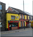
Jen Chang takeaway, Merthyr Tydfil
Located at 15, Lower High Street. Chinese and English meals to take away.
Image: © Jaggery
Taken: 13 Jun 2012
0.03 miles
3
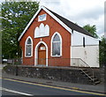
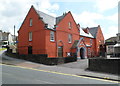
Jerusalem Elim Pentecostal Church, Merthyr Tydfil
The Welsh text in a tablet on the Court Street building shows that it was built in 1911 as a Baptist chapel.
Image: © Jaggery
Taken: 13 Jun 2012
0.04 miles
4
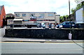
Merthyr Tydfil Labour Club
Set back from Court Street. The advertising hoarding on the right is at the edge of a Merthyr Line railway bridge.
Image: © Jaggery
Taken: 13 Jun 2012
0.04 miles
5
Grade II listed The Court House, Merthyr Tydfil
Located in Court Street. The Court House was built in 1717. Various later modifications and alterations have resulted in little of the original structure remaining. Grade II listed in November 1951.
Image: © Jaggery
Taken: 13 Jun 2012
0.04 miles
6
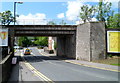
NE side of Court Street railway bridge, Merthyr Tydfil
The bridge is located about 130 metres from Merthyr Tydfil railway station. http://www.geograph.org.uk/photo/2995949
Behind the bridge on the right is Jerusalem Elim Pentecostal Church. http://www.geograph.org.uk/photo/2997860
Image: © Jaggery
Taken: 13 Jun 2012
0.04 miles
7
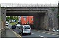
SW side of Court Street railway bridge, Merthyr Tydfil
The bridge is located about 130 metres from Merthyr Tydfil railway station. http://www.geograph.org.uk/photo/2995949
Behind the bridge on the right is Grade II listed The Court House. http://www.geograph.org.uk/photo/2997885
Image: © Jaggery
Taken: 13 Jun 2012
0.04 miles
8
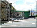
Alfred James & Son, Court Street, Merthyr Tydfil
Funeral directors' premises located next to a railway bridge. http://www.geograph.org.uk/photo/2997923
Image: © Jaggery
Taken: 13 Jun 2012
0.04 miles
9
Farmfoods shop in Merthyr Tydfil
Set back from Court Street.
Image: © Jaggery
Taken: 1 Mar 2019
0.04 miles
10
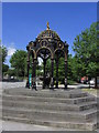
Ironwork fountain by St Tydfil's Old Parish Church, Merthyr Tydfil
Image: © Colin Park
Taken: 17 Jul 2013
0.05 miles