IMAGES TAKEN NEAR TO
High Street, MERTHYR TYDFIL, CF47 8DL
Introduction
This page details the photographs taken nearby to High Street, CF47 8DL by members of the Geograph project.
The Geograph project started in 2005 with the aim of publishing, organising and preserving representative images for every square kilometre of Great Britain, Ireland and the Isle of Man.

There are currently over 7.5m images from over14,400 individuals and you can help contribute to the project by visiting https://www.geograph.org.uk
Image Map
Images are licensed for reuse under creativecommons.org/licenses/by-sa/2.0
Notes
- Clicking on the map will re-center to the selected point.
- The higher the marker number, the further away the image location is from the centre of the postcode.
Image Listing (272 Images Found)
Images are licensed for reuse under creativecommons.org/licenses/by-sa/2.0
Image
Details
Distance
1
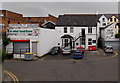
Global Food Store, Merthyr Tydfil
Viewed across Masonic Street, near Merthyr Tydfil railway station. http://www.geograph.org.uk/photo/4031995
Image: © Jaggery
Taken: 16 Jun 2014
0.01 miles
2
High Street, Merthyr Tydfil
Further up the street, a couple of the buildings featured in http://www.geograph.org.uk/photo/2371901 can be seen
Image: © John Baker
Taken: 28 Mar 2011
0.01 miles
3
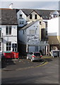
We Buy GOLD, Merthyr Tydfil
We Buy GOLD is on the Jane Allen Jewellers nameboard
on the Masonic Street side of the business at 48 High Street.
Image: © Jaggery
Taken: 1 Mar 2019
0.01 miles
4
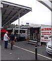
Acorn display booth in Merthyr Tydfil
Displaying samples of Acorn's products near this http://www.geograph.org.uk/photo/4032040 entrance to Beacons Place shopping arcade.
Image: © Jaggery
Taken: 16 Jun 2014
0.01 miles
5
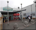
Entrance to Beacons Place, Merthyr Tydfil
Beacons Place is a town centre shopping arcade. The wall on the right details the history
of Merthyr High Street railway station which formerly occupied the adjacent site.
Image: © Jaggery
Taken: 16 Jun 2014
0.01 miles
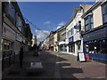
6
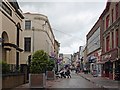
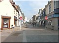
High Street, Merthyr Tydfil
Looking north along a pedestrianised section of the High Street.
High Street Chapel is on the left.
Image: © Robin Drayton
Taken: 21 Jun 2012
0.02 miles
7
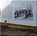
Depiction of a Victorian busy day at High Street station, Merthyr Tydfil
On the wall of a store built on the site of Merthyr Tydfil High Street railway station and yard. The station was designed by Isambard Kingdom Brunel in 1853 in the style of Paddington station which he had designed earlier. At one time, six lines ran through the station. By the 1960s only the Cardiff line remained. As a result the station was too large. It closed in 1962. The present-day station nearby is a one-platform terminus. https://www.geograph.org.uk/photo/6394503
Image: © Jaggery
Taken: 1 Mar 2019
0.02 miles
8
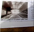
High Street Station 1851-1962, Merthyr Tydfil
On the wall of a store built on the site of Merthyr Tydfil High Street railway station and yard. The station was designed by Isambard Kingdom Brunel in the style of Paddington station which he had designed earlier. At one time, six lines ran through the station. By the 1960s only the Cardiff line remained. As a result the station was too large. It closed in 1962. The present-day station nearby is a one-platform terminus. https://www.geograph.org.uk/photo/6394503
Image: © Jaggery
Taken: 1 Mar 2019
0.02 miles
10
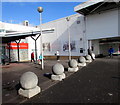
Concrete spheres in Beacons Place, Merthyr Tydfil
Near Merthyr Tydfil railway station and Tesco Extra. https://www.geograph.org.uk/photo/6394704
Image: © Jaggery
Taken: 1 Mar 2019
0.02 miles