IMAGES TAKEN NEAR TO
Eastbourne Place, MERTHYR TYDFIL, CF47 0YF
Introduction
This page details the photographs taken nearby to Eastbourne Place, CF47 0YF by members of the Geograph project.
The Geograph project started in 2005 with the aim of publishing, organising and preserving representative images for every square kilometre of Great Britain, Ireland and the Isle of Man.

There are currently over 7.5m images from over14,400 individuals and you can help contribute to the project by visiting https://www.geograph.org.uk
Image Map
Images are licensed for reuse under creativecommons.org/licenses/by-sa/2.0
Notes
- Clicking on the map will re-center to the selected point.
- The higher the marker number, the further away the image location is from the centre of the postcode.
Image Listing (16 Images Found)
Images are licensed for reuse under creativecommons.org/licenses/by-sa/2.0
Image
Details
Distance
1
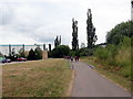
Llwybr Taf yn Rhyd-y-car / Taff Trail at Rhyd-y-car
Cerddwyr yn dilyn Llwybr Taf yn Rhyd-y-car.
Walkers following the Taff Trail at Rhyd-y-car (trans. ford of the cart).
Image: © Alan Richards
Taken: 21 Jul 2018
0.19 miles
2
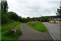
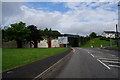
Cycle path beside the leisure centre car park
The path is part of National Cycle Network route 8 and is passing the car park for Merthyr Tydfil leisure centre.
Image: © DS Pugh
Taken: 24 Jun 2024
0.20 miles
3
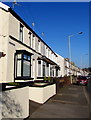
Eastfield Place and Eastfield Terrace, Merthyr Tydfil
Separately-named rows of houses on the west side of Plymouth Street.
The Eastfield Place name sign is on the wall on the left.
Eastfield Terrace is alongside and behind the car.
Image: © Jaggery
Taken: 27 Feb 2019
0.21 miles
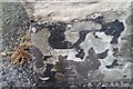
4

Ordnance Survey Cut Mark
This damaged OS cut mark can be found on No1 Eastfield Terrace. It marks a point 163.440m above mean sea level.
Image: © Adrian Dust
Taken: 20 Jul 2020
0.21 miles
5
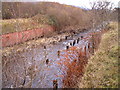
Remains of timber mineral railway bridge
These posts are all that remains of a timber railway bridge across the river Taff near the Rhydycar leisure centre
Image: © nantcoly
Taken: 6 Dec 2005
0.21 miles
6

A blank wall of the Merthyr Tydfil Leisure Centre, by Taff Trail
Image: © David Smith
Taken: 17 Sep 2022
0.22 miles
7
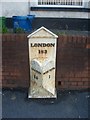
Old Milestone by the A4054, Plymouth Street, Merthyr Tydfil
Simple Gothic by the A4054, in parish of Merthyr Tydfil (Rhondda Cynon Taf County Bor District), in front of 7 Hankey Terrace, Plymouth Street, Merthyr Tydfil, East side of road.
: CARDIFF / 23 : : LONDON / 183 : : MERTHYR / 1 :
Surveyed
Milestone Society National ID: GLA_CFMY23
Image: © Milestone Society
Taken: Unknown
0.22 miles
9
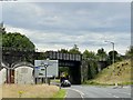
Railway bridge
The bridge over the A4054 is near the end of the Merthyr line, formerly the Taff Vale railway, an important commuter link between Cardiff and Merthyr Tydfil.
Image: © Alan Hughes
Taken: 31 Jul 2020
0.22 miles
10
Ordnance Survey Cut Mark
This OS cut mark can be found on the wall of No21 Rees Street. It marks a point 180.963m above mean sea level.
Image: © Adrian Dust
Taken: 29 Oct 2017
0.23 miles