1
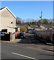
Eastfield Place and Eastfield Terrace, Merthyr Tydfil
Separately-named rows of houses on the west side of Plymouth Street.
The Eastfield Place name sign is on the wall on the left.
Eastfield Terrace is alongside and behind the car.
Image: © Jaggery
Taken: 27 Feb 2019
0.09 miles
2
Ordnance Survey Cut Mark
This damaged OS cut mark can be found on No1 Eastfield Terrace. It marks a point 163.440m above mean sea level.
Image: © Adrian Dust
Taken: 20 Jul 2020
0.09 miles
3
Old Milestone by the A4054, Plymouth Street, Merthyr Tydfil
Simple Gothic by the A4054, in parish of Merthyr Tydfil (Rhondda Cynon Taf County Bor District), in front of 7 Hankey Terrace, Plymouth Street, Merthyr Tydfil, East side of road.
: CARDIFF / 23 : : LONDON / 183 : : MERTHYR / 1 :
Surveyed
Milestone Society National ID: GLA_CFMY23
Image: © Milestone Society
Taken: Unknown
0.10 miles
4
Side road on the northeast side of the A4054 in the south of Merthyr Tydfil
The location of the Plymouth Street name sign https://www.geograph.org.uk/photo/6074293 on the left suggests that this junction
is where the A4054 Pentrebach Road on the right becomes the A4054 Plymouth Street on the left.
Image: © Jaggery
Taken: 27 Feb 2019
0.12 miles
5
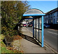
Bench and blue bus shelter, Plymouth Street, Merthyr Tydfil
The stop on the west side of the A4054 Plymouth Street is for
buses to central Merthyr Tydfil and Merthyr Tydfil bus station.
Image: © Jaggery
Taken: 27 Feb 2019
0.13 miles
6
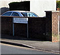
Heol Aberplym/Plymouth Street name sign, Merthyr Tydfil
Welsh/English street name sign on the left here. https://www.geograph.org.uk/photo/6074283
Image: © Jaggery
Taken: 27 Feb 2019
0.13 miles
7
Ford dealership in Merthyr Tydfil
Evans Halshaw Ford Merthyr Tydfil viewed across the A4054 Pentrebach Road.
Image: © Jaggery
Taken: 27 Feb 2019
0.16 miles
8
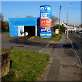
Arc Attended Car Wash in Merthyr Tydfil
Alongside the A4054 in the south of Merthyr Tydfil.
Image: © Jaggery
Taken: 27 Feb 2019
0.16 miles
9
Speedy in Merthyr Tydfil
Speedy Equipment & Tool Hire on the west side of the A4054 Pentrebach Road.
Image: © Jaggery
Taken: 27 Feb 2019
0.18 miles
10
Remains of timber mineral railway bridge
These posts are all that remains of a timber railway bridge across the river Taff near the Rhydycar leisure centre
Image: © nantcoly
Taken: 6 Dec 2005
0.18 miles


