IMAGES TAKEN NEAR TO
Cross Thomas Street, MERTHYR TYDFIL, CF47 0DE
Introduction
This page details the photographs taken nearby to Cross Thomas Street, CF47 0DE by members of the Geograph project.
The Geograph project started in 2005 with the aim of publishing, organising and preserving representative images for every square kilometre of Great Britain, Ireland and the Isle of Man.

There are currently over 7.5m images from over14,400 individuals and you can help contribute to the project by visiting https://www.geograph.org.uk
Image Map
Images are licensed for reuse under creativecommons.org/licenses/by-sa/2.0
Notes
- Clicking on the map will re-center to the selected point.
- The higher the marker number, the further away the image location is from the centre of the postcode.
Image Listing (209 Images Found)
Images are licensed for reuse under creativecommons.org/licenses/by-sa/2.0
Image
Details
Distance
1

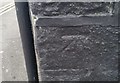
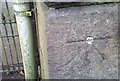
Ordnance Survey Cut Mark
This OS cut mark can be found on No7 Alma Street. It marks a point 184.310m above mean sea level.
Image: © Adrian Dust
Taken: 29 Oct 2017
0.03 miles
2
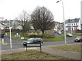
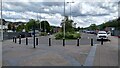
Roundabout on the A4102 near the station in Merthyr Tydfil
Image: © Richard Rogerson
Taken: 31 Jan 2011
0.04 miles
3
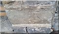
Ordnance Survey Cut Mark
This OS cut mark can be found on the wall of No84 Lower Thomas Street. It marks a point 177.519m above mean sea level.
Image: © Adrian Dust
Taken: 29 Oct 2017
0.05 miles
4
Ordnance Survey Cut Mark
This OS cut mark can be found on the wall of Tydfil House, Union Street. It marks a point 193.764m above mean sea level.
Image: © Adrian Dust
Taken: 29 Oct 2017
0.05 miles
5
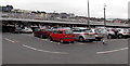
Double-decker Tesco Extra car park, Merthyr Tydfil
Occupying part of the site of the demolished Merthyr High Street railway station.
The adjacent railway station http://www.geograph.org.uk/photo/4031995 is but a shadow of its much bigger predecessor.
Image: © Jaggery
Taken: 16 Jun 2014
0.07 miles
7
Ordnance Survey 1GL Bolt
This OS bolt can be found on the chapel south side of Twynyrodyn Road. It marks a point 183.310m above mean sea level.
Image: © Adrian Dust
Taken: 29 Oct 2017
0.08 miles
8
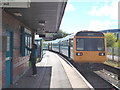
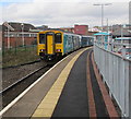
Merthyr Tydfil Station
Once a large station, it is now a single platform, served by half-hourly 'Pacer' trains to Cardiff.
Image: © Dr Neil Clifton
Taken: 9 Sep 2013
0.09 miles
9
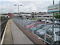
Merthyr Tydfil railway station, Mid Glamorgan, 2011
Opened in 1996 by British Rail at the end of its line from Cardiff via Pontypridd, the line stopped 200m short of the original 1853 Vale of Neath (later Great Western Railway) station which covered most of this site. The GWR 1853 terminus station was reduced to just 2 platforms in 1971 but still fronted John Street. In turn, that was relocated in 1996 to this site, enabling the inevitable supermarket and car park to be built, seen to the right of this image. In 2023, much of the railway line was electrified but no wires had reached here by mid-2024.
Image: © Nigel Thompson
Taken: 28 May 2011
0.09 miles
10
Cardiff Central train at Merthyr Tydfil railway station
On March 1st 2019 the train is Transport for Wales Class 150 diesel multiple unit 150264.
Image: © Jaggery
Taken: 1 Mar 2019
0.09 miles