IMAGES TAKEN NEAR TO
Lower Thomas Street, MERTHYR TYDFIL, CF47 0DA
Introduction
This page details the photographs taken nearby to Lower Thomas Street, CF47 0DA by members of the Geograph project.
The Geograph project started in 2005 with the aim of publishing, organising and preserving representative images for every square kilometre of Great Britain, Ireland and the Isle of Man.

There are currently over 7.5m images from over14,400 individuals and you can help contribute to the project by visiting https://www.geograph.org.uk
Image Map
Images are licensed for reuse under creativecommons.org/licenses/by-sa/2.0
Notes
- Clicking on the map will re-center to the selected point.
- The higher the marker number, the further away the image location is from the centre of the postcode.
Image Listing (226 Images Found)
Images are licensed for reuse under creativecommons.org/licenses/by-sa/2.0
Image
Details
Distance
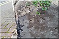
1
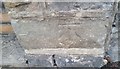
Ordnance Survey Cut Mark
This OS cut mark can be found on the wall of No84 Lower Thomas Street. It marks a point 177.519m above mean sea level.
Image: © Adrian Dust
Taken: 29 Oct 2017
0.01 miles
2
Ordnance Survey Cut Mark
This OS cut mark can be found on the wall east side of Bryntirion Road. It marks a point 201.842m above mean sea level.
Image: © Adrian Dust
Taken: 29 Oct 2017
0.05 miles
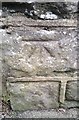
3
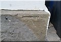
Ordnance Survey Cut Mark
This OS cut mark can be found on No21 Lower Thomas Street. It marks a point 180.807m above mean sea level.
Image: © Adrian Dust
Taken: 29 Oct 2017
0.06 miles
4
Ordnance Survey Cut Mark
This OS cut mark can be found on the wall of Tydfil House, Union Street. It marks a point 193.764m above mean sea level.
Image: © Adrian Dust
Taken: 29 Oct 2017
0.08 miles
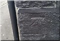
5
Ordnance Survey Cut Mark
This OS cut mark can be found on No7 Alma Street. It marks a point 184.310m above mean sea level.
Image: © Adrian Dust
Taken: 29 Oct 2017
0.08 miles
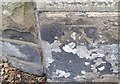
6
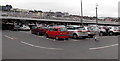
Double-decker Tesco Extra car park, Merthyr Tydfil
Occupying part of the site of the demolished Merthyr High Street railway station.
The adjacent railway station http://www.geograph.org.uk/photo/4031995 is but a shadow of its much bigger predecessor.
Image: © Jaggery
Taken: 16 Jun 2014
0.09 miles
8
Ordnance Survey Cut Mark
This OS cut mark can be found on the wall post of Bryn Heulog, Bryntirion Road. It marks a point 192.673m above mean sea level.
Image: © Adrian Dust
Taken: 29 Oct 2017
0.09 miles
9

Southwest corner of Tesco Extra, Merthyr Tydfil
Located in Beacons Place, Station Yard, Tramroad Side near Merthyr Tydfil railway station.
Image: © Jaggery
Taken: 1 Mar 2019
0.10 miles
10
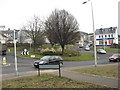
Roundabout on the A4102 near the station in Merthyr Tydfil
Image: © Richard Rogerson
Taken: 31 Jan 2011
0.10 miles