1
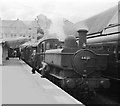
Merthyr Tydfil railway station
This is the 1405 Saturday only branch train to Hirwaun, where a connection will be made with a train to Neath. The original station shown here was demolished in the 1970s and the current station lies to the south west.
Image: © Flying Stag
Taken: 14 Jul 1962
0.03 miles
2
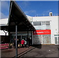
Triangular canopy over the entrance to Beacons Place Shopping Centre, Merthyr Tydfil
Near Merthyr Tydfil railway station viewed in March 2019.
Image: © Jaggery
Taken: 1 Mar 2019
0.04 miles
3
Southwest corner of Tesco Extra, Merthyr Tydfil
Located in Beacons Place, Station Yard, Tramroad Side near Merthyr Tydfil railway station.
Image: © Jaggery
Taken: 1 Mar 2019
0.04 miles
4
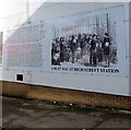
Depiction of a Victorian busy day at High Street station, Merthyr Tydfil
On the wall of a store built on the site of Merthyr Tydfil High Street railway station and yard. The station was designed by Isambard Kingdom Brunel in 1853 in the style of Paddington station which he had designed earlier. At one time, six lines ran through the station. By the 1960s only the Cardiff line remained. As a result the station was too large. It closed in 1962. The present-day station nearby is a one-platform terminus. https://www.geograph.org.uk/photo/6394503
Image: © Jaggery
Taken: 1 Mar 2019
0.05 miles
5
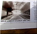
High Street Station 1851-1962, Merthyr Tydfil
On the wall of a store built on the site of Merthyr Tydfil High Street railway station and yard. The station was designed by Isambard Kingdom Brunel in the style of Paddington station which he had designed earlier. At one time, six lines ran through the station. By the 1960s only the Cardiff line remained. As a result the station was too large. It closed in 1962. The present-day station nearby is a one-platform terminus. https://www.geograph.org.uk/photo/6394503
Image: © Jaggery
Taken: 1 Mar 2019
0.05 miles
6
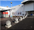
Concrete spheres in Beacons Place, Merthyr Tydfil
Near Merthyr Tydfil railway station and Tesco Extra. https://www.geograph.org.uk/photo/6394704
Image: © Jaggery
Taken: 1 Mar 2019
0.05 miles
7
Entrance to Beacons Place, Merthyr Tydfil
Beacons Place is a town centre shopping arcade. The wall on the right details the history
of Merthyr High Street railway station which formerly occupied the adjacent site.
Image: © Jaggery
Taken: 16 Jun 2014
0.05 miles
8
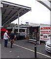
Acorn display booth in Merthyr Tydfil
Displaying samples of Acorn's products near this http://www.geograph.org.uk/photo/4032040 entrance to Beacons Place shopping arcade.
Image: © Jaggery
Taken: 16 Jun 2014
0.06 miles
9
Ordnance Survey Cut Mark
This OS cut mark can be found on No21 Lower Thomas Street. It marks a point 180.807m above mean sea level.
Image: © Adrian Dust
Taken: 29 Oct 2017
0.06 miles
10
High Street, Merthyr Tydfil
Further up the street, a couple of the buildings featured in http://www.geograph.org.uk/photo/2371901 can be seen
Image: © John Baker
Taken: 28 Mar 2011
0.06 miles


