1
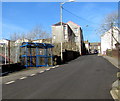
Station Terrace, Bedlinog
Viewed across High Street in February 2019. Station Terrace formerly led to Bedlinog railway station which closed in 1964. The former Station Hotel in High Street is nearby. https://www.geograph.org.uk/photo/6067219
Image: © Jaggery
Taken: 22 Feb 2019
0.01 miles
2
Railway, seen from the road bridge, Bedlinog
Image: © John Lord
Taken: 17 Jul 2010
0.01 miles
3
Entrance to the Gibbons Coaches yard, Bedlinog
From High Street near the corner of Station Terrace.
The sign on the gate on the right shows Gibbons Holidays Booking Office.
Image: © Jaggery
Taken: 22 Feb 2019
0.02 miles
4
Bedlinog Station (remains)
View NW, towards Dowlais; ex-GW & Rhymney Joint Nelson & Llancaiach - Dowlaid (Cae Harris) branch, closed 15/6/64.
Image: © Ben Brooksbank
Taken: 14 Jul 1966
0.02 miles
5
Remains of Bedlinog railway station
Viewed from the High Street railway bridge in February 2019.
This was the site of Bedlinog railway station where passenger services ended in 1964.
The single-track line to Merthyr Tydfil is freight-only.
Image: © Jaggery
Taken: 22 Feb 2019
0.02 miles
6
Site of Bedlinog station
The former down platform and a set of steps remain at Bedlinog, the up platform and station building have long-since been demolished. The steeply-graded railway line runs from Ystrad Mynach to the coal-loading facility at Cwmbargoed, and is freight-only. It currently sees one or two trains a day in each direction during the week.
Image: © Gareth James
Taken: 26 Mar 2018
0.03 miles
7
Coal train in Bedlinog
Class 66 No. 66154 heads north through the site of Bedlinog station with coal empties from Hope to Cwmbargoed.
Image: © Gareth James
Taken: 22 Apr 2022
0.03 miles
8
Blue bus shelter, High Street, Bedlinog
Alongside a stop on bus route 79 from Merthyr Tydfil bus station to Bedlinog
via Troedyrhiw, Merthyr Vale, Treharris and Taff Merthyr Garden Village.
Image: © Jaggery
Taken: 22 Feb 2019
0.03 miles
9
High Street railway bridge, Bedlinog
The bridge carries the B4255 High Street over a single-track railway.
Image: © Jaggery
Taken: 22 Feb 2019
0.03 miles
10
High Street scaffolding, Bedlinog
On the house on the corner of Station Terrace in February 2019.
Image: © Jaggery
Taken: 22 Feb 2019
0.03 miles


