IMAGES TAKEN NEAR TO
Chapel Street, TREHARRIS, CF46 6TS
Introduction
This page details the photographs taken nearby to Chapel Street, CF46 6TS by members of the Geograph project.
The Geograph project started in 2005 with the aim of publishing, organising and preserving representative images for every square kilometre of Great Britain, Ireland and the Isle of Man.

There are currently over 7.5m images from over14,400 individuals and you can help contribute to the project by visiting https://www.geograph.org.uk
Image Map
Images are licensed for reuse under creativecommons.org/licenses/by-sa/2.0
Notes
- Clicking on the map will re-center to the selected point.
- The higher the marker number, the further away the image location is from the centre of the postcode.
Image Listing (144 Images Found)
Images are licensed for reuse under creativecommons.org/licenses/by-sa/2.0
Image
Details
Distance
1

Metal bench at a bend in High Street, Bedlinog
Alongside the B4255 High Street near the Chapel Street junction.
Image: © Jaggery
Taken: 22 Feb 2019
0.02 miles
2

Station Terrace, Bedlinog
Viewed across High Street in February 2019. Station Terrace formerly led to Bedlinog railway station which closed in 1964. The former Station Hotel in High Street is nearby. https://www.geograph.org.uk/photo/6067219
Image: © Jaggery
Taken: 22 Feb 2019
0.03 miles
3
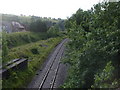
Railway, seen from the road bridge, Bedlinog
Image: © John Lord
Taken: 17 Jul 2010
0.03 miles
4
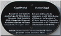
Black bilingual plaque on Moriah Chapel, Bedlinog
The Merthyr Tydfil Heritage Trust plaque in Welsh and English is on the wall on the right here. https://www.geograph.org.uk/photo/6067281
Image: © Jaggery
Taken: 22 Feb 2019
0.03 miles
5

Moriah, Bedlinog
High Street side of Moriah chapel on the corner of Chapel Street. Welsh text on the building records that this is the second rebuild (1901) of the 1876 rebuild of Moriah Independent chapel. The original chapel was erected in 1870.
Image: © Jaggery
Taken: 22 Feb 2019
0.04 miles
6

Entrance to the Gibbons Coaches yard, Bedlinog
From High Street near the corner of Station Terrace.
The sign on the gate on the right shows Gibbons Holidays Booking Office.
Image: © Jaggery
Taken: 22 Feb 2019
0.04 miles
7

High Street scaffolding, Bedlinog
On the house on the corner of Station Terrace in February 2019.
Image: © Jaggery
Taken: 22 Feb 2019
0.04 miles
8
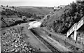
Bedlinog Station (remains)
View NW, towards Dowlais; ex-GW & Rhymney Joint Nelson & Llancaiach - Dowlaid (Cae Harris) branch, closed 15/6/64.
Image: © Ben Brooksbank
Taken: 14 Jul 1966
0.04 miles
9

Remains of Bedlinog railway station
Viewed from the High Street railway bridge in February 2019.
This was the site of Bedlinog railway station where passenger services ended in 1964.
The single-track line to Merthyr Tydfil is freight-only.
Image: © Jaggery
Taken: 22 Feb 2019
0.04 miles
10

Houses on the east side of High Street, Bedlinog
This part of the B4255 High Street is north of Chapel Street and Muriel Terrace.
Image: © Jaggery
Taken: 22 Feb 2019
0.05 miles