IMAGES TAKEN NEAR TO
Bedlinog, TREHARRIS, CF46 6TL
Introduction
This page details the photographs taken nearby to CF46 6TL by members of the Geograph project.
The Geograph project started in 2005 with the aim of publishing, organising and preserving representative images for every square kilometre of Great Britain, Ireland and the Isle of Man.

There are currently over 7.5m images from over14,400 individuals and you can help contribute to the project by visiting https://www.geograph.org.uk
Image Map
Images are licensed for reuse under creativecommons.org/licenses/by-sa/2.0
Notes
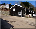
- Clicking on the map will re-center to the selected point.
- The higher the marker number, the further away the image location is from the centre of the postcode.
Image Listing (125 Images Found)
Images are licensed for reuse under creativecommons.org/licenses/by-sa/2.0
Image
Details
Distance
1

Road towards Woodland Cottages, Bedlinog
Descending from the south side of the corner of High Street and Muriel Terrace.
Image: © Jaggery
Taken: 22 Feb 2019
0.01 miles
2

Up the B4255 High Street, Bedlinog
A 14% (1 in 7) gradient sign https://www.geograph.org.uk/photo/6069364 is behind the camera.
Image: © Jaggery
Taken: 22 Feb 2019
0.03 miles
3
Three levels of houses in High Street, Bedlinog
Houses in the background are alongside the steep part of High Street where there is a 14% (1 in 7) gradient.
Image: © Jaggery
Taken: 25 Feb 2019
0.04 miles
4

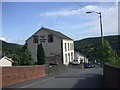
Moriah, Bedlinog
High Street side of Moriah chapel on the corner of Chapel Street. Welsh text on the building records that this is the second rebuild (1901) of the 1876 rebuild of Moriah Independent chapel. The original chapel was erected in 1870.
Image: © Jaggery
Taken: 22 Feb 2019
0.04 miles
5
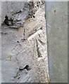
Ordnance Survey Cut Mark
This OS cut mark can be found on No17 Lower High Street. It marks a point 212.805m above mean sea level.
Image: © Adrian Dust
Taken: 7 Oct 2018
0.05 miles
6
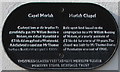
Black bilingual plaque on Moriah Chapel, Bedlinog
The Merthyr Tydfil Heritage Trust plaque in Welsh and English is on the wall on the right here. https://www.geograph.org.uk/photo/6067281
Image: © Jaggery
Taken: 22 Feb 2019
0.05 miles
7

Metal bench at a bend in High Street, Bedlinog
Alongside the B4255 High Street near the Chapel Street junction.
Image: © Jaggery
Taken: 22 Feb 2019
0.05 miles
8

Muriel Terrace, Bedlinog
Dead-end street on the east side of High Street. The trees beyond the end of
the road are above the brook/stream Nant Llwynog, a tributary of the Bargod Taf.
Image: © Jaggery
Taken: 22 Feb 2019
0.05 miles
9
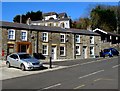
Row of black houses in Bedlinog
Set back from a bend in the B4255 High Street.
Image: © Jaggery
Taken: 22 Feb 2019
0.06 miles