IMAGES TAKEN NEAR TO
Trelewis, TREHARRIS, CF46 6TD
Introduction
This page details the photographs taken nearby to CF46 6TD by members of the Geograph project.
The Geograph project started in 2005 with the aim of publishing, organising and preserving representative images for every square kilometre of Great Britain, Ireland and the Isle of Man.

There are currently over 7.5m images from over14,400 individuals and you can help contribute to the project by visiting https://www.geograph.org.uk
Image Map
Images are licensed for reuse under creativecommons.org/licenses/by-sa/2.0
Notes
- Clicking on the map will re-center to the selected point.
- The higher the marker number, the further away the image location is from the centre of the postcode.
Image Listing (3 Images Found)
Images are licensed for reuse under creativecommons.org/licenses/by-sa/2.0
Image
Details
Distance
1
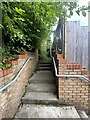
Public footpath
Originally, it appears, from Llancaiach Fawr to Trelewis, this path now runs through a housing estate, echoing its suburban characteristics.
Image: © Alan Hughes
Taken: 17 Jul 2024
0.07 miles
2
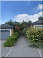
Public footpath between private houses
On the Highfields estate, Trelewis.
Image: © Alan Hughes
Taken: 17 Jul 2024
0.08 miles
3
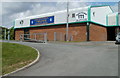
Trelewis Community Centre
The hall is located behind Nant Gwyn and Mackintosh Terrace. There are regular weekly sessions here such as Playgroup Mondays to Thursdays from 9am to 1pm and Trelewis Stay Young at Heart group on Monday afternoons. Room hire is available for meetings of up to 25 people. The sports hall is available for sports usage, parties, discos, large meetings, corporate events or general use.
Image: © Jaggery
Taken: 24 May 2011
0.25 miles